More information about the individual USGS surveys conducted as part of the northern Cape Cod Bay project can be found on the Woods Hole Coastal and Marine Science Center Field Activity webpage:
06012: <http://quashnet.er.usgs.gov/data/2006/06012/> 07001: <http://quashnet.er.usgs.gov/data/2007/07001/> 07002: <http://quashnet.er.usgs.gov/data/2007/07002/> 07003: <http://quashnet.er.usgs.gov/data/2007/07003/> 08002: <http://quashnet.er.usgs.gov/data/2008/08002/>
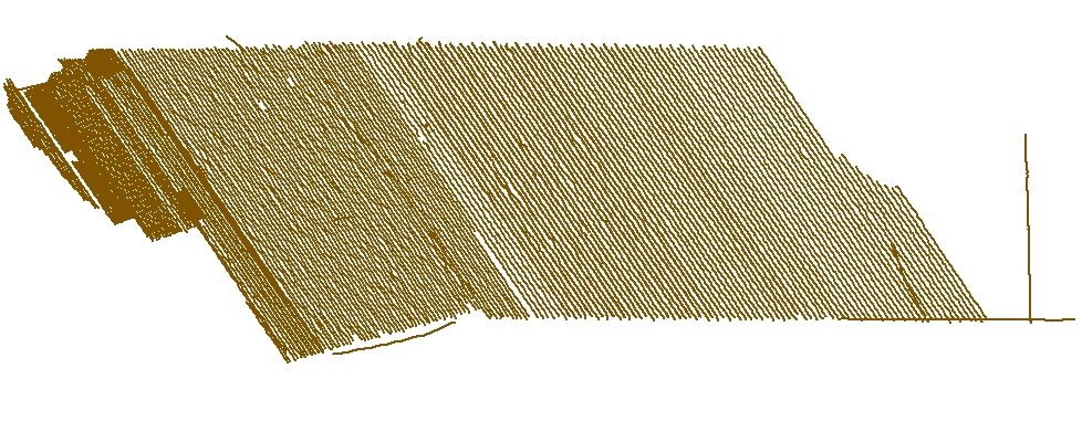
U.S. Geological Survey, 2010, CCB_BackscatterTracklines: Survey lines along which acoustic backscatter data were acquired using a Klein 3000 sidescan sonar and a SWATHplus interferometric sonar offshore of Massachusetts within the northern Cape Cod Bay survey area (ESRI Shapefile, Geographic, WGS84).: Open-File Report 2010-1006, U.S. Geological Survey, Coastal and Marine Geology Program, Woods Hole Coastal and Marine Science Center, Woods Hole, Massachusetts.This is part of the following larger work.Online Links:
- <https://pubs.usgs.gov/of/2010/1006/GIS/shapefile/CCB_BackscatterTracklines.zip>
- <https://pubs.usgs.gov/of/2010/1006/html/appendix1.html>
Andrews, Brian D. , Ackerman, Seth D. , Baldwin, Wayne E. , and Barnhardt, Walter A. , 2010, Geophysical and Sampling Data from the Inner Continental Shelf: Northern Cape Cod Bay, Massachusetts.: Open-File Report 2010-1006, U.S. Geological Survey, Coastal and Marine Geology Program, Woods Hole Coastal and Marine Science Center, Woods Hole, Massachusetts.Online Links:
- http//pubs.usgs.gov/of/2010/1006/
This is a Vector data set. It contains the following vector data types (SDTS terminology):
Horizontal positions are specified in geographic coordinates, that is, latitude and longitude. Latitudes are given to the nearest 0.000001. Longitudes are given to the nearest 0.000001. Latitude and longitude values are specified in Decimal degrees.
The horizontal datum used is D_WGS_1984.
The ellipsoid used is WGS_1984.
The semi-major axis of the ellipsoid used is 6378137.000000.
The flattening of the ellipsoid used is 1/298.257224.
Sequential unique whole numbers that are automatically generated.
Coordinates defining the features.
Character string of width 25
Character string of width 10
| Range of values | |
|---|---|
| Minimum: | 0.0024 |
| Maximum: | 9.76 |
| Units: | kilometers (km) |
508-548-8700 x2348 (voice)
508-457-2310 (FAX)
[email protected]
The purpose of these data is to provide the trackline navigation and filenames of the 3,009 km of acoustic backscatter data acquired using a Klein 3000 sidescan sonar and a SWATHplus interferometric sonar in the northern Cape Cod Bay survey area.
Acoustic backscatter data acquisition for field activities 07001 and 08002: The Klein 3000 towfish was deployed from a davit on the port side of the R/V Rafael approximately 1 m astern and 0.5 m below the water surface.
Swath width was 100 m either side of the vessel (200 m total) for field activities 06012, 07001 and 08002. Swath width for field activity 07002 was increased to 150 m range (300 m total) because tracklines we spaced 150 m apart.
Person who carried out this activity:
508-548-8700 x2348 (voice)
508-457-2310 (FAX)
[email protected]
Person who carried out this activity:
508-548-8700 x2348 (voice)
508-457-2310 (FAX)
[email protected]
Person who carried out this activity:
508-548-8700 x2348 (voice)
508-457-2310 (FAX)
[email protected]
Person who carried out this activity:
508-548-8700 x2348 (voice)
508-457-2310 (FAX)
[email protected]
Barnhardt, Walter A. , Andrews, Brian D. , and Butman, Bradford, 2006, High-Resolution Mapping of the Inner Continental Shelf: Nahant to Gloucester, Massachusetts: Open-File Report 2005-1293, U.S. Geological Survey, Coastal and Marine Geology Program, Woods Hole Science Center, Woods Hole, MA.Online Links:
Ackerman, Seth D. , Butman, Bradford, Barnhardt, Walter A. , Danforth, William W. , and Crocker, James M. , 2006, High-Resolution Geologic Mapping of the Inner Continental Shelf: Boston Harbor and Approaches, Massachusetts: Open-File Report 2006-1008, U.S. Geological Survey, Coastal and Marine Geology Program, Woods Hole Science Center, Woods Hole, MA.Online Links:
Barnhardt, Walter A. , Andrews, Brian D. , Ackerman, Seth D. , Baldwin, Wayne E. , and Hein, Christopher J. , 2009, High-Resolution Geological Mapping of the Inner Continental Shelf: Cape Ann to Salisbury Beach, Massachusetts: Open-File Report 2007-1373, U.S. Geological Survey, Coastal and Marine Geology Program, Woods Hole Science Center, Woods Hole, MA.Online Links:
Barnhardt, Walter A. , Ackerman, Seth D. , Andrews, Brian D. , and Baldwin, Wayne E. , 2010, Geophysical and Sampling Data from the Inner Continental Shelf: Duxbury to Hull, Massachusetts: Open-File Report 2009-1072, U.S. Geological Survey, Coastal and Marine Geology Program, Woods Hole Science Center, Woods Hole, Massachusetts.Online Links:
Danforth, William W. , 1997, XSonar/ShowImage: A complete system for rapid sidescan-sonar processing and display.: Open-File Report 97-686, U.S. Geological Survey, Woods Hole Science Center, Woods Hole, MA.Online Links:
All attributes were checked in a consistent manner.
Field activities 06012 and 07002: The Klein 3000 towfish was deployed from the stern A-frame of the R/V Megan T. Miller. Real-time kinematic (RTK) GPS navigation data were provided by an Ashtech Z-Extreme receiver (an Ashtech BR2G DGPS was used as a backup system) and recorded to the raw data files (XTF) via the Klein SonarPro (version 9.6 & 10.0) acquisition software. During some portions of the survey, technical difficulties caused the GPS systems to malfunction and lose the "fixed" RTK signal. When this occurred, the navigation system generally defaulted to a "float" RTK or DGPS signal, or the navigation was lost. When possible, surveying was halted until a reliable GPS signal was restored. A digital cable counter attached to the winch used to deploy the sidescan-sonar towfish measured changes in the amount of cable extended from the A-frame and updated the cable out parameter in SonarPro. Using the cable out value and linear offset between the A-frame and the RTK-GPS antenna (mounted mid-ship on the starboard side directly above the SWATHplus transducers), Sonar Pro calculated towfish layback positions in real time and recorded them to the XTF file headers. A conservative estimate of positional accuracy is ± 10 m, but when the navigation system was providing the "fixed" RTK signal, positional accuracy is likely < 1 m. Positional uncertainty arises because layback calculations do not account for fish motion behind the vessel, which is caused by sea state and vessel speed induced changes in the angle and scope of the tow cable.
Field Activity 07002 SEA SWATHplus backscatter: The winch used to deploy and retrieve the Klein 3000 towfish was inoperable between Aug 1-2, 2007. During this time, the acoustic backscatter collected with the 117 kHz SEA SWATHplus interferometric sonar was used to fill the gap in the Klein 3000 backscatter. The SWATHplus transducers were mounted on a rigid pole, approximately 2.6 m below the water line, along the starboard side of the R/V Megan T. Miller. Real-time kinematic (RTK) GPS navigation data were provided by an Ashtech Z-Surveyor Extreme receiver (an Ashtech BR2G DGPS was used as a backup navigation system) and recorded to the raw data files (SXR) via the SWATHplus (version 2.07) acquisition software. A conservative estimate of positional accuracy is likely <1 m.
Field activities 07001 and 08002: The Klein 3000 towfish was deployed from a davit on the port side aft on the R/V Rafael at a fixed distance that was accounted for during acquisition. Real-time kinematic (RTK) GPS navigation data were provided by an Ashtech Z-Surveyor Extreme receiver and recorded to the raw data files (XTF) via the Klein SonarPro (version 9.6 and 10.0) acquisition software. A conservative estimate of positional accuracy is ± 10 m, but when the navigation system was providing the "fixed" RTK signal, positional accuracy is likely <1 m.
Only the subset of sidescan-sonar trackline navigation data collected during field activities 06012 and 07001 that are within the northern Cape Cod Bay study area between Duxbury Beach and Provincetown have been included in this spatial dataset. This dataset includes all the tracklines collected during field activities 07002 and 08002.
Any spurious data points were removed during processing. Duplicate names may exist for the FILENAME attribute because this is made up of data from multiple surveys; however further querying the data by SURVEY attribute will distinguish a unique trackline for each record in this spatial dataset.
Are there legal restrictions on access or use of the data?
- Access_Constraints: None
- Use_Constraints:
- Public domain data from the U.S. Government are freely redistributable with proper metadata and source attribution. Please recognize the U.S. Geological Survey as the source of this information.
508-548-8700 x2348 (voice)
[email protected]
Downloadable Data
Neither the U.S. Government, the Department of the Interior, nor the USGS, nor any of their employees, contractors, or subcontractors, make any warranty, express or implied, nor assume any legal liability or responsibility for the accuracy, completeness, or usefulness of any information, apparatus, product, or process disclosed, nor represent that its use would not infringe on privately owned rights. The act of distribution shall not constitute any such warranty, and no responsibility is assumed by the USGS in the use of these data or related materials. Any use of trade, product, or firm names is for descriptive purposes only and does not imply endorsement by the U.S. Government.
| Data format: | Trackline navigation for acoustic backscatter collected within the northern Cape Cod Bay survey area. in format SHP (version ArcGIS 9.3) ESRI polyline shapefile Size: 0.541 |
|---|---|
| Network links: |
<https://pubs.usgs.gov/of/2010/1006/GIS/shapefile/CCB_BackscatterTracklines.zip> |
| Media you can order: |
DVD-ROM
(Density 4.75
Gbytes)
(format UDF)
|
This zip file contains data available in Environmental Systems Research Institute (ESRI) shapefile format. The user must have software capable of uncompressing the WinZip file and displaying the shapefile. In lieu of ArcView or ArcGIS, the user may utilize another GIS application package capable of importing the data. A free data viewer, ArcExplorer, capable of displaying the data is available from ESRI at www.esri.com.
508-548-8700 x2348 (voice)
508-457-2310 (FAX)
[email protected]