U.S. Geological Survey Open-File Report 2010-1070
ABSTRACT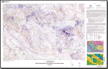
This aeromagnetic map of Joshua Tree National Park and vicinity is intended to promote further understanding of the geology and structure in the region by serving as a basis for geophysical interpretations and by supporting geological mapping, water-resource investigations, and various topical studies. Local spatial variations in the Earth's magnetic field (evident as anomalies on aeromagnetic maps) reflect the distribution of magnetic minerals, primarily magnetite, in the underlying rocks. In many cases the volume content of magnetic minerals can be related to rock type, and abrupt spatial changes in the amount of magnetic minerals commonly mark lithologic or structural boundaries. Bodies of mafic and ultramafic rocks tend to produce the most intense magnetic anomalies, but such generalizations must be applied with caution because rocks with more felsic compositions, or even some sedimentary units, also can cause measurable magnetic anomalies. The database includes two ASCII files containing new aeromagnetic data and two ASCII files with point locations of the local maximum horizontal gradient derived from the aeromagnetic data. This metadata file describes the horizontal gradient locations derived from new and existing aeromagnetic data. This aeromagnetic map identifies magnetic features as a basis for geophysical interpretations; the gradients help define the edges of magnetic sources. This database updates geophysical information originally presented in smaller-scale formats and includes detailed aeromagnetic data collected by EON Geosciences, Inc. |
MetadataData
For additional information: Part of this report is presented in Portable Document Format (PDF); the latest version of Adobe Reader or similar software is required to view it. Download the latest version of Adobe Reader, free of charge. |
Langenheim, V.E., and Hill, P.L., 2010, Preliminary aeromagnetic map of Joshua Tree National Park and vicinity, southern California: U.S. Geological Survey Open-File Report 2010-1070, scale 1:100,000.

![]() U.S. Department of the Interior |
U.S. Geological Survey
U.S. Department of the Interior |
U.S. Geological Survey
URL: http://
pubsdata.usgs.gov
/pubs/of/2010/1070/index.html
Page Contact Information: USGS Publications Team
Page Last Modified: Wednesday, 07-Dec-2016 22:34:04 EST
