Open-File Report 2010–1094
1 U.S. Geological Survey, Woods Hole Coastal and Marine Science Center, Woods Hole, MA 02543.
2 Present address: NOAA Great Lakes Environmental Research Laboratory, Ann Arbor, MI 48108.
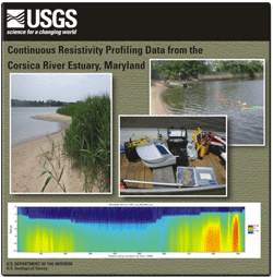
AbstractSubmarine groundwater discharge (SGD) into Maryland's Corsica River Estuary was investigated as part of a larger study to determine its importance in nutrient delivery to the Chesapeake Bay. The Corsica River Estuary represents a coastal lowland setting typical of much of the eastern bay. An interdisciplinary U.S. Geological Survey (USGS) science team conducted field operations in the lower estuary in April and May 2007. Resource managers are concerned about nutrients that are entering the estuary via SGD that may be contributing to eutrophication, harmful algal blooms, and fish kills. Techniques employed in the study included continuous resistivity profiling (CRP), piezometer sampling of submarine groundwater, and collection of a time series of radon tracer activity in surface water. A CRP system measures electrical resistivity of saturated subestuarine sediments to distinguish those bearing fresh water (high resistivity) from those with saline or brackish pore water (low resistivity). This report describes the collection and processing of CRP data and summarizes the results. Based on a grid of 67.6 kilometers of CRP data, low-salinity (high-resistivity) groundwater extended approximately 50–400 meters offshore from estuary shorelines at depths of 5 to >12 meters below the sediment surface, likely beneath a confining unit. A band of low-resistivity sediment detected along the axis of the estuary indicated the presence of a filled paleochannel containing brackish groundwater. The meandering paleochannel likely incised through the confining unit during periods of lower sea level, allowing the low-salinity groundwater plumes originating from land to mix with brackish subestuarine groundwater along the channel margins and to discharge. A better understanding of the spatial variability and geological controls of submarine groundwater flow beneath the Corsica River Estuary could lead to improved models and mitigation strategies for nutrient over-enrichment in the estuary and in other similar settings. |
Posted September 20, 2011 For additional information contact: Part or all of this report is presented in Portable Document Format (PDF); the latest version of Adobe Reader or similar software is required to view it. Download the latest version of Adobe Reader, free of charge. |
Cross, V.A., Bratton, J.F., Worley, C.R., Crusius, J., and Kroeger, K.D., 2011, Continuous resistivity profiling data from the Corsica River Estuary, Maryland: U.S. Geological Survey Open-File Report 2010-1094, 1 DVD. (Also available at https://pubs.usgs.gov/of/2010/1094/.
Abstract
Introduction
Methods
Profile Previews
Summary
Data Catalog
Acknowledgements
References Cited
Glossary

![]() U.S. Department of the Interior |
U.S. Geological Survey
U.S. Department of the Interior |
U.S. Geological Survey
URL: http://pubsdata.usgs.gov/pubs/of/2010/1094/index.html
Page Contact Information: GS Pubs Web Contact
Page Last Modified: Wednesday, 07-Dec-2016 23:28:48 EST
