High-Resolution Seismic-Reflection Data Offshore of Dana Point, Southern California Borderland
Frequently-Anticipated Questions
Metadata also available as - [Outline] - [Parseable text] - [XML]
Frequently-anticipated questions:
- Title: Data Tables
- Abstract:
-
This report consists of high-resolution shallow seismic-reflection profile data
from the offshore area between Dana Point and San Mateo Point
in southern Orange and northern San Diego Counties, California.
These data were acquired in 2006 using the Research Vessel
Sea Explorer (USGS Field Activity ID: S-2-06-SC).
The data are available in binary, TIFF and JPEG image formats.
Binary data are in Society of Exploration Geologists (SEG)
SEG-Y format and may be downloaded for further processing or display.
Reference maps and JPEG images of the profiles may be viewed
with your Web browser.
- Supplemental_Information:
-
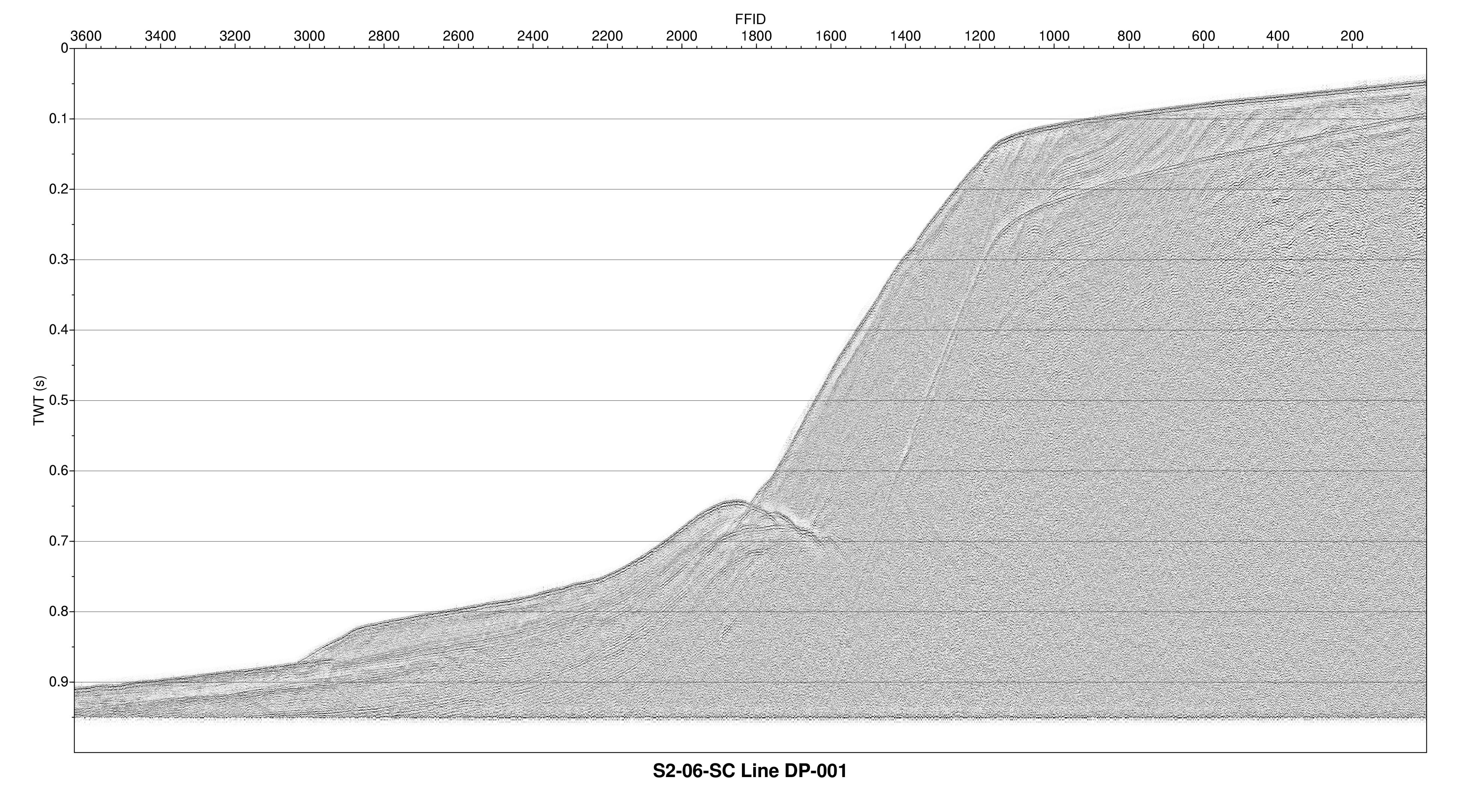
Mini-sparker profiles are collected with a 500 Joule sparker source and
15-m single-channel streamer towed at the sea surface.
The acoustic energy is reflected at density boundaries
(such as the sea floor or sediment layers beneath the sea floor),
and detected by the hydrophone array, and
digitally recorded by the onboard PC-based acquisition system.
As the vessel moves, this process is repeated multiple times
per second, producing a two-dimensional image of the shallow
geologic structure beneath the ship track.
Additional information about the USGS field activity S-2-06-SC is available at
<http://walrus.wr.usgs.gov/infobank/s/s206sc/html/s-2-06-sc.meta.html>.
- How should this data set be cited?
Sliter, Ray W. , Ryan, Holy F. , and Triezenberg, Peter J. , 2010, Data Tables:.
This is part of the following larger work.
Sliter, Ray W. , Ryan, Holy F. , and Triezenberg, Peter J. , 2010, High-Resolution Seismic Reflection Data Offshore of Dana Point, Southern California Borderland: U.S. Geological Survey Open-File Report 2010-1111, U.S. Geological Survey, Menlo Park, CA.
Online Links:
- What geographic area does the data set cover?
- West_Bounding_Coordinate: -117.84953
- East_Bounding_Coordinate: -117.51352
- North_Bounding_Coordinate: 33.56004
- South_Bounding_Coordinate: 33.20846
- What does it look like?
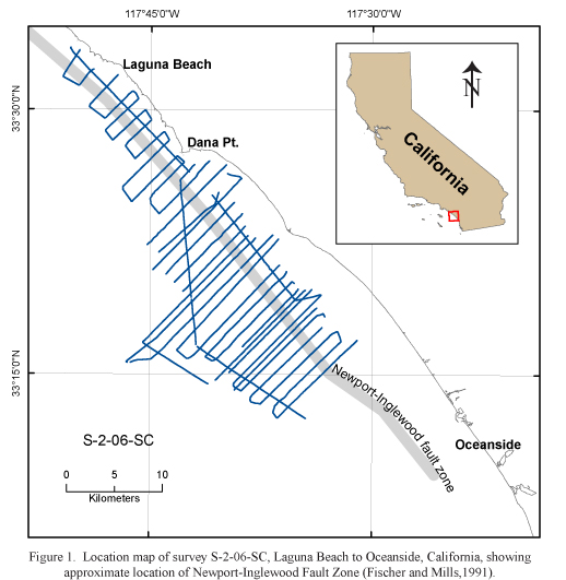
- <https://pubs.usgs.gov/of/2010/1111/figures/original/figure1.jpg> (JPEG)
-
Location map of single-channel mini-sparker seismic data
accessible via this report.
- <https://pubs.usgs.gov/of/2010/1111/tracklines/sparker/jpg/DP-001.jpg> (JPEG)
-
Example of single-channel mini-sparker seismic data
accessible via this report.
- Does the data set describe conditions during a particular time period?
- Beginning_Date: 01-Sep-2006
- Ending_Date: 08-Sep-2006
- Currentness_Reference: ground condition
- What is the general form of this data set?
- Geospatial_Data_Presentation_Form: seismic reflection profile section
- How does the data set represent geographic features?
- How are geographic features stored in the data set?
- Indirect_Spatial_Reference:
-
Horizontal X and Y locations for the seimic profiles location
are provided in ASCII position files and are also stored
in the SEG-Y data trace headers in the standard header locations.
- What coordinate system is used to represent geographic features?
- Grid_Coordinate_System_Name: Universal Transverse Mercator
- Universal_Transverse_Mercator:
-
- UTM_Zone_Number: 11
- Transverse_Mercator:
-
- Scale_Factor_at_Central_Meridian: 0.9996
- Longitude_of_Central_Meridian: -117.0
- Latitude_of_Projection_Origin: 0.0
- False_Easting: 500000
- False_Northing: 0
Planar coordinates are encoded using coordinate pair
Abscissae (x-coordinates) are specified to the nearest 3
Ordinates (y-coordinates) are specified to the nearest 3
Planar coordinates are specified in seconds
The horizontal datum used is World Geodetic System 1984.
The ellipsoid used is WGS 84.
The semi-major axis of the ellipsoid used is 6378137.
The flattening of the ellipsoid used is 1/298.257.
- How does the data set describe geographic features?
- Entity_and_Attribute_Overview:
-
Ascii data sets
s-2-06-sc.410_060 has
initial header records followed by data records
with these fields -
4-digit year, 3-digit day of year, 2-digit hour,
2-digit minute, 2-digit second, 1-digit tenth of second,
decimal degree latitude, decimal degree longitude,
alpha-numeric line ID, FFID number, Shot number, and CDP number.
Example:
					! /infobank/s/s206sc/seis/s-2-06-sc.410_060
					! time/lat/long style, multi-record, in caps, without tabs
					! (Year, Day, Hour, Min, Sec, Tenths, Latitude, Longitude, Line, FFID, Shot, CDP, Comment)
					! (i4.4, i3.3, 3i2.2, i1.1, t16, f9.5, t26, f10.5, t37, a12, t50, i9, t60, i9, t70, i9, t80, a)
					! (%4.4i%3.3i3%2.2i%1.1i %9.5f %10.5f %12s %9i %9i %9i %s\\n)
					! temporal domain
					! data acquisition systems
					! use value = -9999 for null FFID, Shot, or CDP
					!
					!*09/18/2006 ray /we/ray/410files/s-2-06-sc.410_scms
					! /infobank/programs/edit/mergeit/mergeit
					!
					!        1         2         3         4         5         6         7         8         9
					! 3456789012345678901234567890123456789012345678901234567890123456789012345678901234567890
					!
					20062452243000  33.42198 -117.67355       DP-001         1         1     -9999
					20062452243010  33.42196 -117.67356       DP-001         2         2     -9999
					20062452243020  33.42194 -117.67357       DP-001         3         3     -9999
					20062452243030  33.42193 -117.67357       DP-001         4         4     -9999
					20062452243040  33.42191 -117.67358       DP-001         6         6     -9999
					20062452243050  33.42189 -117.67359       DP-001         7         7     -9999
					20062452243060  33.42187 -117.67360       DP-001         8         8     -9999
					20062452243070  33.42185 -117.67361       DP-001         9         9     -9999
					20062452243090  33.42182 -117.67362       DP-001        10        10     -9999
- Entity_and_Attribute_Detail_Citation:
-
U.S. Geological Survey,
USGS CMG InfoBank format for Seismic FFID/Shot/CDP data,
2010,
<http://walrus.wr.usgs.gov/infobank/programs/html/dictionary2html/format_410.html>.
- Who are the originators of the data set? (may include formal authors, digital compilers, and editors)
- Ray W. Sliter
- Holy F. Ryan
- Peter J. Triezenberg
- Who also contributed to the data set?
The authors thank Rick Baker of the Ocean Institute at Dana Point
along with the captain and crew of R/V Sea Explorer
for assistance in the acquisition of the mini-sparker data.
- To whom should users address questions about the data?
U.S. Geological Survey (USGS), Coastal and Marine Geology (CMG)
c/o Ray W. Sliter
Geophysicist
USGS, MailStop 999, 345 Middlefield Road
Menlo Park, CA 94025-3561
USA
650-329-5194 (voice)
650-329-5190 (FAX)
rsliter@usgs.gov
In September 2008, the U.S. Geological Survey (USGS) collected seismic-reflection
in an area from as far north as Laguna Beach, Orange County, CA
to offshore of Oceanside, San Diego County, CA (cruise S-2-06-SC, Figure 1).
Reflection profiles were located to provide information
on the geometric representations of offshore faults and recency of fault activity.
The profiles were primarily oriented perpendicular to the shore (NE-SW)
in waters depths from mid-shelf to the base of the slope.
Data acquisition focused on the imaging of blind thrust faults and folds
that had been proposed to lie beneath much of offshore Orange and San Diego Counties
(the Oceanside fault) and the offshore Newport-Inglewood fault zone.
- From what previous works were the data drawn?
- How were the data generated, processed, and modified?
- Date: 2008 (process 1 of 7)
-
Refer to report sections "Data Acquisition and Processing"
for details of geophysical
data acquisition and processing sequence used
for data in this report.
- Ray W. Sliter
- Date: 2009 (process 2 of 7)
-
Created bathymetry overlay using GMT
<http://gmt.soest.hawaii.edu/>.
- Peter J. Triezenberg
- Date: 2009 (process 3 of 7)
-
Created interactive trackline map using Google Maps API
<http://code.google.com/apis/maps/>.
- Peter J. Triezenberg
- Date: 2009 (process 4 of 7)
-
Created downloadable Google Earth "kmz" file
<http://code.google.com/apis/kml/>.
- Peter J. Triezenberg
- Date: 2008 (process 5 of 7)
-
Created seismic profile images using Seismic Unix
<http://www.cwp.mines.edu/cwpcodes/>
to provide format options for downloading data.
- Ray W. Sliter
Person who carried out this activity:
U.S. Geological Survey (USGS), Coastal and Marine Geology (CMG)
c/o Ray W. Sliter
Geophysicist
USGS, MailStop 999, 345 Middlefield Road
Menlo Park, CA 94025-3561
USA
(650) 329-5194 (voice)
(650) 329-5190 (FAX)
rsliter@usgs.gov
- Date: 2009 (process 6 of 7)
-
Converted profiles to TIFF and JPEG files using ImageMagick
<http://www.imagemagick.org/>.
- Peter J. Triezenberg
- Date: 2008 (process 7 of 7)
-
Used GEODAS (GEOphysical DAta System) to create
a custom bathymetric and topographic grid
for the southern California region covered
by the cruise maps.
The website is:
<http://www.ngdc.noaa.gov/mgg/geodas/geodas.html>.
The parameters used are as follows:
Grid Database: US Coastal Relief Model Grids
Grid Area in degrees and minutes:
34:30 N to 33:48 N, 119:00 W to 120:24 W
Grid Cell Size: 3 seconds
Grid Format: XYZ (lon, lat, depth), no header,
space-delimited, omit empty grid cells.
Cell Parameters: 4-byte floating point, tenths of meters
Land/Sea Coverage: Sea cells only.
- Peter J. Triezenberg
Person who carried out this activity:
U.S. Geological Survey (USGS), Coastal and Marine Geology (CMG)
c/o Peter J. Triezenberg
Geologist
USGS, MailStop 999, 345 Middlefield Road
Menlo Park, CA 94025-3561
USA
(650) 329-5207 (voice)
(650) 329-5190 (FAX)
ptriezenberg@usgs.gov
- What similar or related data should the user be aware of?
U.S. Geological Survey (USGS), Coastal and Marine Geology (CMG), 2008, USGS CMG S-2-06-SC Metadata.
Online Links:
- How well have the observations been checked?
Data have not been independently verified.
- How accurate are the geographic locations?
Shot point numbers in the data files correspond
to those in the navigation files.
The horizontal positional accuracy of the seismic data thus
linked to ship's position is estimated to be within 30 meters.
- How accurate are the heights or depths?
Depths shown in the seismic data files are
in milliseconds (round trip travel time) and
are referenced to sea level.
- Where are the gaps in the data? What is missing?
Reference the full report for a description of data coverage.
All seismic-reflection data collected on the referenced cruises
have been included in this report.
Some seismic profiles have gaps in them due
to system crashes, mammal shutdowns or hardware maintenance.
- How consistent are the relationships among the observations, including topology?
Undetermined
Are there legal restrictions on access or use of the data?
- Access_Constraints:
-
Information presented in this publication is considered public information and
may be distributed or copied.
- Use_Constraints:
-
Not suitable for navigation
Read and fully comprehend the metadata prior to data use.
Acknowledge the U.S. Geological Survey (USGS), the Originator, when using the data set
as a source. Any use of trade, firm, or product names is for descriptive purposes only
and does not imply endorsement by the U.S. Government.
Share data products developed using the source data set with the Originator.
Data should not be used beyond the limits of the source scale. This information is
not intended for navigational purposes.
The data set is NOT a survey document and should not be utilized as such. Some USGS
information accessed through this means may be preliminary in nature and presented
without the approval of the Director of the USGS. This information is provided with
the understanding that it is not guaranteed to be correct or complete and conclusions
drawn from such information are the responsibility of the user.
- Who distributes the data set? (Distributor 1 of 1)
U.S. Geological Survey (USGS), Coastal and Marine Geology (CMG)
c/o Ray W. Sliter
Geophysicist
USGS, MailStop 999, 345 Middlefield Road
Menlo Park, CA 94025-3561
USA
(650) 329-5194 (voice)
(650) 329-5190 (FAX)
rsliter@usgs.gov
- Contact_Instructions:
-
Data may be available off-line only by special
arrangement with the distributor above. Please use the on-line
download option unless precluded by download times or access
difficulties.
- What's the catalog number I need to order this data set?
U.S. Geological Suvey Open-File Report 2010-1111
- What legal disclaimers am I supposed to read?
Information presented in this publication is considered public information and
may be distributed or copied.
Please recognize the U.S. Geological Survey (USGS) as
the source of this information.
This information is not intended for navigational purposes.
Any use of trade, product, or firm names is for descriptive purposes only and
does not imply endorsement by the U.S. Government.
Some USGS information accessed through this means may be preliminary in nature and
presented without the approval of the Director of the USGS.
This information is provided with the understanding that it is not guaranteed
to be correct or complete and conclusions drawn from such information
are the responsibility of the user.
- How can I download or order the data?
- Availability in digital form:
- Cost to order the data: None
- What hardware or software do I need in order to use the data set?
Use of SEG-Y data requires specialized software,
such as ProMax and Seisworks by Landmark Geophysical;
FOCUS and SeisX by Paradigm Geophysical;
SPW by Parallel Geoscience;
or VISTA by Seismic Image Software.
- Dates:
- Last modified: 16-Feb-2010
- Metadata author:
-
U.S. Geological Survey (USGS), Coastal and Marine Geology (CMG)
c/o Ray W. Sliter
Geophysicist
USGS, MailStop 999, 345 Middlefield Road
Menlo Park, CA 94025-3561
USA
(650) 329-5194 (voice)
(650) 329-5190 (FAX)
rsliter@usgs.gov
- Metadata standard:
- FGDC Content Standards for Digital Geospatial Metadata (FGDC-STD-001-1998)
Accessibility | FOIA | Privacy | Policies and Notices
U.S. Department of the Interior | U.S. Geological Survey
URL: https://pubs.usgs.gov/of/2010/1111/
Maintained by: Mike Diggles
Page last modified and
Generated by mp version 2.9.8 on Tue Apr 13 11:01:13 2010
|

