SolVES
Ecosystem Services Social Values Model
The Ecosystem Services Social Values Model works in conjunction with the Value Mapping Model to generate Value Index maps and landscape metrics describing the location and attibutes of areas that selected survey respondents value for reasons such as aesthetics, biodiversity, or recreation. The Ecosystem Services Social Values Model must be processes before the Value Mapping Model is used. It allows for the selection of a particular public use and an attitude or preference regarding that use for a subgroup of survey respondents. If no use and atittude or preference are selected, the model will run for all survey respondents; however, if either the public use or the attitude or preference parameter is selected, then both must be selected. Once the model finishes processing, a table named ClusterStats can be accessed through the ArcMap table of contents Source tab. The table includes average nearest neighbor statistics for each of the 12 social value types. The user can use these statistics to identify specific social value types they would like to examine using the Value Mapping Model. The Value Mapping Model can be processed repeatedly for each social value type of interest. For additional information regarding the Ecosystem Services Social Values Model, select the "Tool Help" button or consult the SolVES user manual.
Illustration
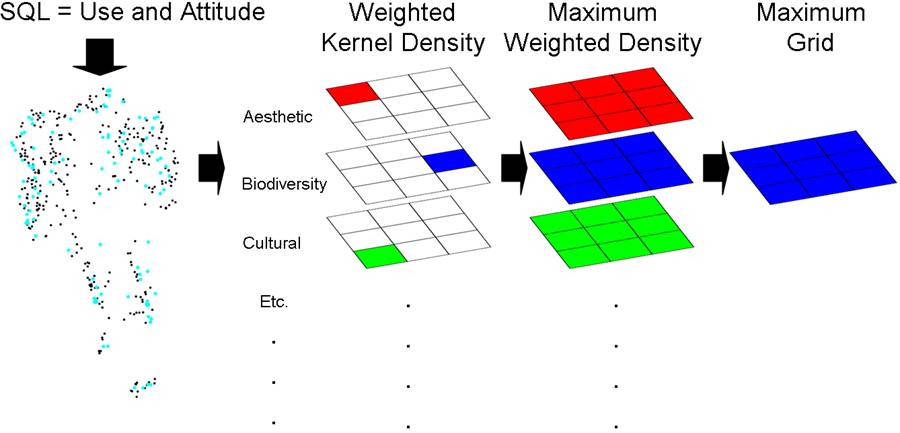
The Ecosystem Services Social Values Model generates weighted kernel density surfaces for each of 12 social value types. It then identifies the maximum value contained in each of these grids. Finally, it generates a constant "Maximum Grid" containing the highest single value found among all the weighted kernel density surfaces.
Command line syntax
Ecosystem_Services_Social_Values_Model {Sightseeing | Sport Fishing | Non-Motorized Recreation | Sport Hunting | Helicopter Skiing and Hiking | Wildlife Viewing and Observing | Motorized Recreation | Logging for Fuels Reduction | Commercial Mining | Gathering Forest Products | Logging for Increased Water Collection | Oil and Gas Drilling | Logging for Wood Products | Commercial Outfitting and Guiding | Communication Sites and Utility Easements | Wilderness | Fish and Wildllife Habitat | Other} {Favor or Strongly Favor | Oppose or Strongly Oppose}
Parameters
| Expression |
Explanation |
| {Sightseeing | Sport Fishing | Non-Motorized Recreation | Sport Hunting | Helicopter Skiing and Hiking | Wildlife Viewing and Observing | Motorized Recreation | Logging for Fuels Reduction | Commercial Mining | Gathering Forest Products | Logging for Increased Water Collection | Oil and Gas Drilling | Logging for Wood Products | Commercial Outfitting and Guiding | Communication Sites and Utility Easements | Wilderness | Fish and Wildllife Habitat | Other} |
Select the desired public use from the dropdown list. The available uses are:
- Sightseeing (including driving for pleasure)
- Non-Motorized Recreation (e.g., hiking, canoeing)
- Helicopter Skiing and Hiking
- Wildlife Viewing and Observing
- Motorized Recreation (e.g., snowmobiles, ATVs, jet-skiing)
- Logging for Fuels Reduction
- Gathering Forest Products (e.g., berries, mushrooms)
- Logging for Increased Water Collection
- Logging for Wood Products
- Commercial Outfitting and Guiding
- Communication Sites and Utility Easements
- Fish and Wildlife Habitat
|
| {Favor or Strongly Favor | Oppose or Strongly Oppose} |
Select the desired attitude or preference regarding the selected public use.
|
Scripting syntax
Ecosystem_Services_Social_Values_Model (Public_Use, Attitude_or_Preference)
Parameters
| Expression |
Explanation |
| Public Use (Optional) |
Select the desired public use from the dropdown list. The available uses are:
- Sightseeing (including driving for pleasure)
- Non-Motorized Recreation (e.g., hiking, canoeing)
- Helicopter Skiing and Hiking
- Wildlife Viewing and Observing
- Motorized Recreation (e.g., snowmobiles, ATVs, jet-skiing)
- Logging for Fuels Reduction
- Gathering Forest Products (e.g., berries, mushrooms)
- Logging for Increased Water Collection
- Logging for Wood Products
- Commercial Outfitting and Guiding
- Communication Sites and Utility Easements
- Fish and Wildlife Habitat
|
| Attitude or Preference (Optional) |
Select the desired attitude or preference regarding the selected public use.
|
Model
Elements
| Name |
Explanation |
| Create File GDB (2) |
Creates the Results file geodatabase for final data.
|
| Create File GDB |
Creates the Scratch file geodatabase for intermediate data.
|
| Survey_Parameters_Submodel |
Converts user-entered public use and attitude or preference paramaters to a SQL statement which is used to select appropriate point features.
|
| Make Feature Layer |
Creates a feature layer from points selected by the Survey_Parameters_Submodel.
|
| Value_Allocation_Stats_Submodel |
Calculates the total value allocated to each social value type, which is later used for weighting kernel density surfaces.
|
| Add Join |
Joins the total allocated values calculated by the Value_Allocation_Stats_Submodel to their associated selected point features.
|
| Copy Features |
Copies the joined points and values to a seperate feature class to be processed by the Kernel_Density_Submodel.
|
| Kernel_Density_Submodel |
Calculates the weighted kernel density surface for each of the 12 social value types and generates a Maximum Grid. Also calculates the average nearest neighbor statistics for each of the 12 social value types. Currently all kernel densities are calculated with a search radius of 5000 meters and an output cell size of 450 meters.
|