SolVES

Value Mapping Model

The Value Mapping Model can only be processed after processing the Ecosystem Services Social Values Model. The Value Mapping Model can be processed repeatedly to generate Value Index maps and landscape metrics for the 12 social value types associated with the subgroup of survey respondents selected using the Ecosystem Services Social Values Model. For additional information regarding the Value Mapping Model, select the "Tool Help" button or consult the SolVES user manual.


Illustration


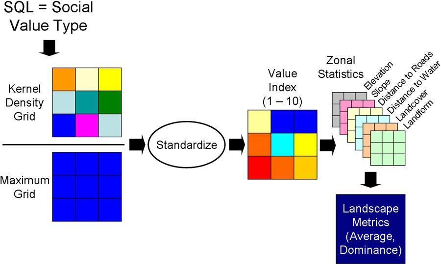
The Value Mapping Model normalizes the user-selected social value type against the Maximum Grid generated by the Ecosystem Services Social Values Mapping Model. It standardizes the normalized grid to generate the Value Index. The integer values contained in the Value Index grid define zones which are then used to generate landscape statistics.

Command line syntax

Value_Mapping_Model <Aesthetic | Biodiversity | Cultural | Economic | Future | Historic | Intrinsic | Learning | Life_Sustaining | Recreation | Spiritual | Therapeutic>

Parameters
Expression Explanation
<Aesthetic | Biodiversity | Cultural | Economic | Future | Historic | Intrinsic | Learning | Life_Sustaining | Recreation | Spiritual | Therapeutic>

Select the desired social value type from the dropdown list.

  • Aesthetic: Scenery, sights, sounds, smells, etc.
  • Biodiversity: Variety of fish, wildlife, plant life, etc.
  • Cultural: Places to continue and pass down the wisdom and knowledge, traditions, and ancestral way of life.
  • Economic: Provide timber, fisheries, minerals, and/or tourism opportunites such as outfitting and guiding.
  • Future: Allow future generations to know and experience the area as it is now.
  • Historic: Places and things of natural and human history that matter personally, to others, or the nation.
  • Intrinsic: Value in and of itself, whether people are present or not.
  • Learning: Opportunities to learn about the environment through scientific observation or experimentation.
  • Life Sustaining: Produce, preserve, clean, and renew air, soil, and water.
  • Recreation: Places for favorite outdoor recreation activities.
  • Spiritual: Sacred, religious, or spiritually special place or inspiring feelings of reverence and respect for nature.
  • Therapeutic: Improve physical and/or mental well-being.

Scripting syntax

Value_Mapping_Model (Value_Type)

Parameters
Expression Explanation
Value Type (Required)

Select the desired social value type from the dropdown list.

  • Aesthetic: Scenery, sights, sounds, smells, etc.
  • Biodiversity: Variety of fish, wildlife, plant life, etc.
  • Cultural: Places to continue and pass down the wisdom and knowledge, traditions, and ancestral way of life.
  • Economic: Provide timber, fisheries, minerals, and/or tourism opportunites such as outfitting and guiding.
  • Future: Allow future generations to know and experience the area as it is now.
  • Historic: Places and things of natural and human history that matter personally, to others, or the nation.
  • Intrinsic: Value in and of itself, whether people are present or not.
  • Learning: Opportunities to learn about the environment through scientific observation or experimentation.
  • Life Sustaining: Produce, preserve, clean, and renew air, soil, and water.
  • Recreation: Places for favorite outdoor recreation activities.
  • Spiritual: Sacred, religious, or spiritually special place or inspiring feelings of reverence and respect for nature.
  • Therapeutic: Improve physical and/or mental well-being.

Model

Elements
Name Explanation
Value_Map_Type

A script that accepts the user-entered value type parameter and returns the appropriate weighted kernel density grid.

Calculate Field

Writes the name of the user-selected value type parameter to the Eco_Soc_Values source file geodatabase for later use in labeling and naming output.

Square Root

As part of the standardization process to generate the Value Index, the square root of the weighted kernel density grid is calculated in order to compress the range of values contained in the grid.

Divide

Normalizes the weighted kernel density grid by dividing it by the Maximum Grid generated by the Ecosystem Services Social Values Model.

Plus

Adds 0.5 to the normalized grid so values will be properly rounded when converted to integers in the Value Index.

Int

Converts the normalized grid to the 10-point Value Index grid.

Landscape_Metrics_Submodel

Calculates landscape metrics using the 10-point Value Index grid.

Times

Multiplies the normalized grid by 10 to generate an alternate 100-point Value Index for use in calculating landscape metrics that will be used in statitstical analysis external from SolVES.

Plus (2)

Adds 0.5 to the normalized grid so values will be properly rounded when converted to integers in the Value Index.

Int (2)

Converts the normalized grid to the 100-point Value Index grid.

Landscape_Metrics_100_Scale_Submodel

Calculates landscape metrics using the 100-point Value Index grid.