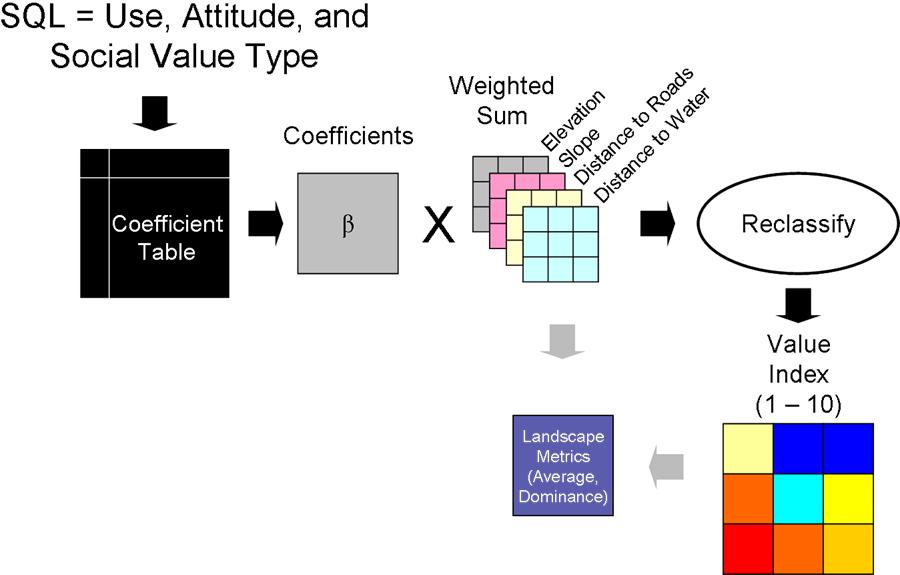
The Value Transfer Mapping Model applies regression coefficients calculated from the multiple regression of the Value Index with various landscape metrics to produce predicted Value Index maps for areas where public attititude and preference survey data are not available. For additional information regarding the Value Transfer Mapping Model, select the "Tool Help" button or consult the SolVES user manual.
Expression | Explanation |
---|---|
{Sightseeing | Sport Fishing | Non-Motorized Recreation | Sport Hunting | Helicopter Skiing and Hiking | Wildlife Viewing and Observing | Motorized Recreation | Logging for Fuels Reduction | Commericial Mining | Gathering Forest Products | Logging for Increased Water Collection | Oil and Gas Drilling | Logging for Wood Products | Commercial Outfitting and Guiding | Communication Sites and Utility Easements | Wilderness | Fish and Wildlife Habitat | Other} |
Select the desired public use from the dropdown list. The available uses are:
|
{Favor or Strongly Favor | Oppose or Strongly Oppose} |
Select the desired attitude or preference regarding the selected public use. |
<Aesthetic | Biodiversity | Cultural | Economoic | Future | Historic | Intrinsic | Learning | Life_Sustaining | Recreation | Spiritual | Therapeutic> |
Select the desired social value type from the dropdown list.
|
Expression | Explanation |
---|---|
Public Use (Optional) |
Select the desired public use from the dropdown list. The available uses are:
|
Attitude or Preference (Optional) |
Select the desired attitude or preference regarding the selected public use. |
Value Type (Required) |
Select the desired social value type from the dropdown list.
|
Name | Explanation |
---|---|
Resample |
Resamples 30-meter data to 450-meter data to match the resolution at which coefficients were calculated. |
Create File GDB |
Creates the Sratch file geodatabase for intermediate data. |
Transfer_Parameters_Submodel |
Converts the user-entered public use, attitude or preference, and value type parameters to a SQL statement which is then used to retrieve the appropriate regression coefficients from the Coefficients table in the Eco_Soc_Values source file geodatabase. |
Get_Coefficients |
Assigns each retrieved coefficient to a separate variable that will be referenced by the Weighted Sum tool. |
Resample (2) |
Resamples 30-meter data to 450-meter data to match the resolution at which coefficients were calculated. |
Resample (3) |
Resamples 30-meter data to 450-meter data to match the resolution at which coefficients were calculated. |
Resample (4) |
Resamples 30-meter data to 450-meter data to match the resolution at which coefficients were calculated. |
Reclassify (2) |
Generates a constant grid representing the extent of the landscape data layers that will be used to generate the weighted sum surface. |
Weighted Sum |
Applies each coefficient to its corresponding landscape data layer and sums the results to produce a weighted value surface. |
Create File GDB (2) |
Creates the Results file geodatabase for final data. |
Reclassify |
Reclassifies the weighted surface to generate the 10-point Value Index grid. Values less than 0.5 (including negative values) are reclassified to 0. Values greater than 10 are reclassified to 10. |
Landscape_Metrics_Submodel |
Calculates landscape metrics using the 10-point Value Index grid. |