Open-File Report 2010–1230
Summary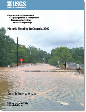
Heavy rains in southern Georgia during March 27–April 3, 2009, and in northern Georgia during September 16–22, 2009, caused severe flooding and widespread damages to residential, public, and commercial structures. Of the 159 counties in Georgia, 69 were declared disaster areas because of flooding. The heavy rainfall in southern Georgia resulted in severe flooding in the Satilla–St. Marys and upper Ochlockonee Basins and caused approximately $60 million in damages to the public infrastructure. The heavy rainfall in northern Georgia resulted in severe flooding on many streams within the upper Chattahoochee, Altamaha, and Coosa–Tallapoosa Basins and caused 10 deaths, evacuation of thousands of residents, and approximately $500 million in damages. The U.S. Geological Survey computed annual exceedance probabilities of the peak flows in 2009 at 238 streamgages throughout the State. Record peak flows were recorded at 40 streamgages for the respective periods of record as a result of the heavy rainfall during the two multiday events. The peak flows at 33 streamgages exceeded the 1-percent annual exceedance probability (100-year recurrence interval), and 19 of these exceeded the 0.2-percent annual exceedance probability (500-year recurrence interval). |
First posted September 29, 2010 For additional information contact: Part or all of this report is presented in Portable Document Format (PDF); the latest version of Adobe Reader or similar software is required to view it. Download the latest version of Adobe Reader, free of charge. |
Gotvald, A.J., 2010, Historic flooding in Georgia, 2009: U.S. Geological Survey Open-File Report 2010-1230, 19 p.
Abstract
Introduction
Purpose and Scope
Abstract
Introduction
Purpose and Scope
Description of Storms Associated with the Floods
Description of the Floods
Flood Stages and Streamflows
Annual Exceedance Probabilities
Summary
Acknowledgments
References Cited

![]() U.S. Department of the Interior |
U.S. Geological Survey
U.S. Department of the Interior |
U.S. Geological Survey
URL: http://
pubsdata.usgs.gov
/pubs/of/2010/1230/index.html
Page Contact Information: USGS Publications Team
Page Last Modified: Wednesday, 07-Dec-2016 22:42:24 EST
