U.S. Geological Survey Open-File Report 2010–1301
Introduction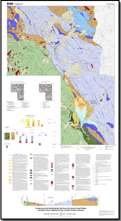
The Lake Pillsbury area lies in the eastern part of the northern California Coast Ranges, along the east side of the transform boundary between the Pacific and North American plates (fig. 1). The Bartlett Springs Fault Zone is a northwest-trending zone of faulting associated with this eastern part of the transform boundary. It is presently active, based on surface creep (Svarc and others, 2008), geomorphic expression, offset of Holocene units (Lienkaemper and Brown, 2009), and microseismicity (Bolt and Oakeshott, 1982; Dehlinger and Bolt, 1984; DePolo and Ohlin, 1984). Faults associated with the Bartlett Springs Fault Zone at Lake Pillsbury are steeply dipping and offset older low to steeply dipping faults separating folded and imbricated Mesozoic terranes of the Franciscan Complex and interleaved rocks of the Coast Range Ophiolite and Great Valley Sequence. Parts of this area were mapped in the late 1970s and 1980s by several investigators who were focused on structural relations in the Franciscan Complex (Lehman, 1978; Jordan, 1975; Layman, 1977; Etter, 1979). In the 1980s the U.S. Geological Survey (USGS) mapped a large part of the area as part of a mineral resource appraisal of two U.S. Forest Service Roadless areas. For evaluating mineral resource potential, the USGS mapping was published at a scale of 1:62,500 as a generalized geologic summary map without a topographic base (Ohlin and others, 1983; Ohlin and Spear, 1984). The previously unpublished mapping with topographic base is presented here at a scale of 1:30,000, compiled with other mapping in the vicinity of Lake Pillsbury. The mapping provides a geologic framework for ongoing investigations to evaluate potential earthquake hazards and structure of the Bartlett Springs Fault Zone. This geologic map includes part of Mendocino National Forest (the Elk Creek Roadless Area) in Mendocino, Glenn, and Lake Counties and is traversed by several U.S. Forest Service Routes, including M1 and M6 (fig. 2). The study area is characterized by northwest-trending ridges separated by steep-sided valleys. Elevations in this part of the Coast Ranges vary from 1,500 ft (457 m) to 6,600 ft (2,012 m), commonly with gradients of 1,000 ft per mile (90 m per km). The steep slopes are covered by brush, grass, oak, and conifer forests. Access to most of the area is by county roads and Forest Service Route M6 from Potter Valley to Lake Pillsbury and by county road and Forest Service Route M6 and M1 from Upper Lake and State Highway 20. From the north, State Highway 261 provides access from Covelo. Forest Service Route M1 trends roughly north from its intersection with Route M6 south of Hull Mountain and through the Elk Creek and Black Butte Roadless areas to State Highway 261. Side roads used for logging and jeep trails provide additional access in parts of the area. |
Last modified September 4, 2012
Files for viewing and plotting
GIS data
For additional information: Part of this report is presented in Portable Document Format (PDF); the latest version of Adobe Reader or similar software is required to view it. Download the latest version of Adobe Reader, free of charge. |
Ohlin, H.N., McLaughlin, R.J., Moring, B.C., and Sawyer, T.L., 2010, Geologic map of the Bartlett Springs Fault Zone in the vicinity of Lake Pillsbury and adjacent areas of Mendocino, Lake, and Glenn Counties, California: U.S. Geological Survey Open-File Report 2010–1301, scale 1:30,000. (Available at https://pubs.usgs.gov/sim/3125/.)

![]() U.S. Department of the Interior |
U.S. Geological Survey
U.S. Department of the Interior |
U.S. Geological Survey
URL: http://pubsdata.usgs.gov/pubs/of/2010/1301/index.html
Page Contact Information: GS Pubs Web Contact
Page Last Modified: Wednesday, 07-Dec-2016 23:02:00 EST
