EC_250M_AEA_NAD27.TIF - U.S. Atlantic East Coast EEZ GLORIA sidescan-sonar composite mosaic (ACEA, 250 m, Clarke1866)

Metadata also available as - [Outline] - [Parseable text]

Frequently-anticipated questions:


What does this data set describe?

Title:
EC_250M_AEA_NAD27.TIF - U.S. Atlantic East Coast EEZ GLORIA sidescan-sonar composite mosaic (ACEA, 250 m, Clarke1866)
Abstract:
From February to May 1987 the U.S. Geological Survey (USGS) conducted five cruises to cover the U.S. Atlantic Continental Margin Exclusive Economic Zone (EEZ) seaward of the continental shelf edge, and from the Canadian border southward to the northern Blake Plateau off Florida. As in earlier EEZ reconnaissance surveys, the USGS utilized the GLORIA (Geological LOng-Range Inclined Asdic) sidescan-sonar system to complete the geologic mapping. The collected GLORIA data were processed and digitally mosaicked to produce continuous imagery of the sea-floor. A total of 23 digital mosaics of a 2 degree by 2 degree (or smaller) area with a 50-meter pixel resolution were completed for the U.S. Atlantic Continental Margin.
Supplemental_Information:
Two of the mosaics contained in this composite mosaic have not been previously released. These mosaics, numbers 22 and 23, were obtained outside of the U.S. Exclusive Economic Zone and were not included in the original publications or data releases. They complete a southern extension of the original released mosaic and are located north of the Bahamas.
  1. How should this data set be cited?

    U.S. Geological Survey, 2011, EC_250M_AEA_NAD27.TIF - U.S. Atlantic East Coast EEZ GLORIA sidescan-sonar composite mosaic (ACEA, 250 m, Clarke1866): Open-File Report 2010-1332, U.S. Geological Survey, Coastal and Marine Geology Program, Pacific Coastal and Marine Science Center, Menlo Park, CA.

    Online Links:

    This is part of the following larger work.

    Paskevich, Valerie F. , Wong, Florence L. , O'Malley, John J. , Stevenson, Andrew J. , and Gutmacher, Christina E. , 2011, GLORIA Sidescan-Sonar Imagery for Parts of the U.S. Exclusive Economic Zone and Adjacent Areas: Open-File Report 2010-1332, U.S. Geological Survey, Coastal and Marine Geology Program, Pacific Coastal and Marine Science Center, Menlo Park, CA.

    Online Links:

  2. What geographic area does the data set cover?

    West_Bounding_Coordinate: -80.000000
    East_Bounding_Coordinate: -63.028393
    North_Bounding_Coordinate: 42.189539
    South_Bounding_Coordinate: 24.500199

  3. What does it look like?

    <https://pubs.usgs.gov/of/2010/1332/gloria_data/atlantic_coast/composite/browse/ec_250m_aea_nad27-thumb.gif> (GIF)
    Thumbnail image showing an overview of the U.S. Atlantic East Coast GLORIA composite mosaic.
    <https://pubs.usgs.gov/of/2010/1332/gloria_data/atlantic_coast/composite/browse/ec_250m_aea_nad27.gif> (GIF)
    Browse image showing an overview of the U.S. Atlantic East Coast GLORIA composite mosaic.

  4. Does the data set describe conditions during a particular time period?

    Beginning_Date: 02-Feb-1987, 19870301, 19870328, 19870427, 19870509
    Ending_Date: 27-Feb-1987, 19870326, 19870425, 19870508, 19870528
    Currentness_Reference: ground condition

  5. What is the general form of this data set?

    Geospatial_Data_Presentation_Form: remote-sensing image

  6. How does the data set represent geographic features?

    1. How are geographic features stored in the data set?

      This is a Raster data set. It contains the following raster data types:

      • Dimensions 7736 x 5586 x 1, type Pixel

    2. What coordinate system is used to represent geographic features?

      The map projection used is Albers Conical Equal Area.

      Projection parameters:
      Standard_Parallel: 45.500000
      Standard_Parallel: 29.500000
      Longitude_of_Central_Meridian: -73.000000
      Latitude_of_Projection_Origin: 0.000000
      False_Easting: 0.000000
      False_Northing: 0.000000

      Planar coordinates are encoded using row and column
      Abscissae (x-coordinates) are specified to the nearest 250.000000
      Ordinates (y-coordinates) are specified to the nearest 250.000000
      Planar coordinates are specified in meters

      The horizontal datum used is North American Datum of 1927.
      The ellipsoid used is Clarke 1866.
      The semi-major axis of the ellipsoid used is 6378206.400000.
      The flattening of the ellipsoid used is 1/294.978698.

  7. How does the data set describe geographic features?

    ec_250m_aea_nad27.tif.vat

    ObjectID
    Internal feature number. (Source: ESRI)

    Sequential unique whole numbers that are automatically generated.

    Value

    Count

    Entity_and_Attribute_Overview:
    There are no attributes associated with a GeoTIFF image. Image pixel values contain acoustic reflectivity values normalized to an 8-bit data range (0-255). Low-backscatter is represented by dark tones (low values) and high-backscatter is represented by bright tones (high values). These data have NOT been radiometrically enhanced.


Who produced the data set?

  1. Who are the originators of the data set? (may include formal authors, digital compilers, and editors)

  2. Who also contributed to the data set?

    Public domain data from the U.S. Government are freely redistributable with proper metadata and source attribution. The U.S. Geological Survey (USGS) must be referenced as the originator of the dataset in any future products or research derived from these data.

  3. To whom should users address questions about the data?

    U.S. Geological Survey
    c/o Valerie Paskevich
    Information Specialist / GIS Coordinator, retired
    384 Woods Hole Road
    Woods Hole, MA 02543-1598
    USA

    (508) 548-8700 (voice)
    (508) 457-2310 (FAX)


Why was the data set created?

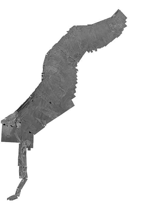
This remote sensing image of the sea-floor is a reduced-resolution (250-meter) composite mosaic of the 23 mosaics created from the U.S. Atlantic East coast GLORIA sidescan-sonar data.


How was the data set created?

  1. From what previous works were the data drawn?

    U.S. Atlantic East Coast GLORIA mosaics 1-23 (source 1 of 1)
    Type_of_Source_Media: disc
    Source_Contribution:
    The 23 completed 50-meter mosaics were combined to create an Albers Equal Area (AEA) Conic projection, 250-meter composite overview.

  2. How were the data generated, processed, and modified?

    Date: 01-May-2006 (process 1 of 3)
    An empty PCI database for the full extent of the U.S. Atlantic East Coast GLORIA was defined. The imagery database was defined with an Albers Equal Area (AEA) Conic projection at a resolution of 250-meters. Standard parallels of 29.5 and 45.5 and a central longitude of -73 were selected with a Clarke 1866 spheroid (NAD27).

    Person who carried out this activity:

    U.S. Geological Survey
    c/o Valerie Paskevich
    Information Specialist / GIS Coordinator, retired
    384 Woods Hole Road
    Woods Hole, MA 02543-1598
    USA

    (508) 548-8700 (voice)
    (508) 457-2310 (FAX)

    Data sources produced in this process:
    • ec_250m_aea_nad27.pix

    Date: 01-May-2006 (process 2 of 3)
    Using the PCI Geomatics tool GCPworks, the 23 individual 50-meter mosaics were combined to create a composite overview of the U.S. Atlantic East Coast GLORIA data at a resolution of 250-meters. The individual full-resolution GLORIA mosaics with the white flood-filled background were mosaiced together to create a single reduced-resolution composite mosaic for the U.S. Atlantic East Coast. Individual mosaics were "dropped" into the composite database. No rubber sheeting or geometric corrections were applied to the mosaics. However, some mosaics were radiometrically enhanced to reduce the effect of the individual square boundaries and produce a more uniform overview image. The individual 23 mosaics were combined using a bi-linear resampling mode to reduce noise and blockiness.

    Person who carried out this activity:

    U.S. Geological Survey
    c/o Valerie Paskevich
    Information Specialist / GIS Coordinator, retired
    384 Woods Hole Road
    Woods Hole, MA 02543-1598
    USA

    (508) 548-8700 (voice)
    (508) 457-2310 (FAX)

    Data sources used in this process:
    • ec_q01.tif
    • ec_q02.tif
    • ec_q03.tif
    • ec_q04.tif
    • ec_q05.tif
    • ec_q06.tif
    • ec_q07.tif
    • ec_q08.tif
    • ec_q09.tif
    • ec_q10.tif
    • ec_q11.tif
    • ec_q12.tif
    • ec_q13.tif
    • ec_q14.tif
    • ec_q15.tif
    • ec_q16.tif
    • ec_q17.tif
    • ec_q18.tif
    • ec_q19.tif
    • ec_q20.tif
    • ec_q21.tif
    • ec_q22.tif
    • ec_q23.tif
    • ec_250m_aea_nad27.pix

    Data sources produced in this process:

    • ec_250m_aea_nad27.pix

    Date: 02-May-2006 (process 3 of 3)
    The completed reduced 250-meter mosaic was exported from the PCI database as a GeoTIFF image with associated world file.

    Person who carried out this activity:

    U.S. Geological Survey
    c/o Valerie Paskevich
    Information Specialist / GIS Coordinator, retired
    384 Woods Hole Road
    Woods Hole, MA 02543-1598
    USA

    (508) 548-8700 (voice)
    (508) 457-2310 (FAX)

    Data sources used in this process:
    • ec_250m_aea_nad27.pix

    Data sources produced in this process:

    • ec_250m_aea_nad27.tif
    • ec_250m_aea_nad27.tfw

  3. What similar or related data should the user be aware of?

    EEZ-SCAN 87 Scientific Staff, 1991, Atlas of the Exclusive Economic Zone, Atlantic continental margin: Miscellaneous Investigation Series I-2054, U.S. Geological Survey, Reston, VA.

    Other_Citation_Details: 174 p.
    (editor), J.V. Gardner , (editor), M.E. Field , and (editor), D.C. Twichell , 1996, Geology of the United States Seafloor: The View from GLORIA: Cambridge University Press, Cambridge, U.K..

    Jr., P.S. Chavez , 1986, Processing Techniques for Digital Sonar Images from GLORIA: Photogrammetric Engineering and Remote Sensing Vol. 52, No. 8, August 1986, p. 1133-1145, American Society for Photogrammetry and Remote Sensing, Falls Church, VA 22046.

    Jr., P.S. Chavez , 1984, U.S. Geological Survey mini image processing system (MIPS): Open-File Report 84-880, U.S. Geological Survey, Reston, VA.

    Paskevich, V., 1997, Digital Mosaics of the GLORIA Sidescan Sonar Data of the U.S. Atlantic East Coast: Open-File Report 97-853, U.S. Geological Survey, Coastal and Marine Geology Program, Woods Hole Science Center, Woods Hole, MA.

    Other_Citation_Details: 2 CD-ROM


How reliable are the data; what problems remain in the data set?

  1. How well have the observations been checked?

    There are no attributes associated with the GeoTIFF image.

  2. How accurate are the geographic locations?

    Primary navigational control for this survey was by Loran-C supplemented by satellite navigation. Accuracy of location of the navigation fixes is estimated to be better than 100 meters.

  3. How accurate are the heights or depths?

  4. Where are the gaps in the data? What is missing?

    All available imagery were used to create this mosaic. Data were acquired during several cruises using the 6.5 kHz GLORIA sidescan-sonar system and a 45 km total swath width.

  5. How consistent are the relationships among the observations, including topology?

    not applicable


How can someone get a copy of the data set?

Are there legal restrictions on access or use of the data?

Access_Constraints: None
Use_Constraints:
Public domain data from the U.S. Government are freely redistributable with proper metadata and source attribution. Please recognize the U.S. Geological Survey as the originator of the dataset.

  1. Who distributes the data set? (Distributor 1 of 2)

    U.S. Geological Survey
    384 Woods Hole Road
    Woods Hole, MA 02543-1598
    USA

    (508) 548-8700 (voice)
    (508) 457-2310 (FAX)

  2. What's the catalog number I need to order this data set?

    Downloadable Data

  3. What legal disclaimers am I supposed to read?

    Neither the U.S. Government, the Department of the Interior, nor the USGS, nor any of their employees, contractors, or subcontractors, make any warranty, express or implied, nor assume any legal liability or responsibility for the accuracy, completeness, or usefulness of any information, apparatus, product, or process disclosed, nor represent that its use would not infringe on privately owned rights. The act of distribution shall not constitute any such warranty, and no responsibility is assumed by the USGS in the use of these data or related materials. Any use of trade, product, or firm names is for descriptive purposes only and does not imply endorsement by the U.S. Government.

  4. How can I download or order the data?

  5. What hardware or software do I need in order to use the data set?

    The composite sidescan-sonar mosaic is available as a GeoTIFF image with accompanying world file and georeference report. To utilize this data, the user must have an image viewer, image processing or GIS software package capable of importing a GeoTIFF image. If the georeferencing information cannot be imported, the user may wish to view the georeference information contained in a separate file included in the zip file.


  1. Who distributes the data set? (Distributor 2 of 2)

    U.S. Geological Survey
    345 Middlefield Road MS 999
    Menlo Park, CA 94025
    USA

    (650) 329-5078 (voice)
    (650) 329-5190 (FAX)

  2. What's the catalog number I need to order this data set?

    Downloadable Data

  3. What legal disclaimers am I supposed to read?

    Neither the U.S. Government, the Department of the Interior, nor the USGS, nor any of their employees, contractors, or subcontractors, make any warranty, express or implied, nor assume any legal liability or responsibility for the accuracy, completeness, or usefulness of any information, apparatus, product, or process disclosed, nor represent that its use would not infringe on privately owned rights. The act of distribution shall not constitute any such warranty, and no responsibility is assumed by the USGS in the use of these data or related materials. Any use of trade, product, or firm names is for descriptive purposes only and does not imply endorsement by the U.S. Government.

  4. How can I download or order the data?

  5. What hardware or software do I need in order to use the data set?

    The sidescan-sonar mosaic is available as a GeoTIFF image with accompanying world file and georeference report. To utilize this data, the user must have an image viewer, image processing or GIS software package capable of importing a GeoTIFF image. If the georeferencing information cannot be imported, the user may wish to obtain the georeference information contained in a separate file included in the zip file.


Who wrote the metadata?

Dates:
Last modified: 29-Mar-2011
Metadata author:
U.S. Geological Survey
c/o Valerie Paskevich
Information Specialist / GIS Coordinator, retired
384 Woods Hole Road
Woods Hole, MA 02543-1598
USA

(508) 548-8700 (voice)
(508) 457-2310 (FAX)

Metadata standard:
FGDC Content Standards for Digital Geospatial Metadata (FGDC-STD-001-1998)
Metadata extensions used:


Generated by mp version 2.9.8 on Thu Mar 31 11:28:55 2011