Skip past header information
USGS - science for a changing world
NOAA Logo with link to NOAA Home Page.Massachusetts CZM Logo with link to MA CZM Home Page.  

U.S. Geological Survey Open-File Report 2011–1004

Sea-Floor Geology and Character of Eastern Rhode Island Sound West of Gay Head, Massachusetts


Skip past contents information

Title | List of Figures | Conversion Factors | Abstract | Introduction | Setting | Methods | Bathymetry | Sediment Distribution | Bottom Photography | GIS Data Catalog | Summary | Acknowledgments | References | Contacts


Figure 20. An image of the sea-floor bathymetry in the study area.

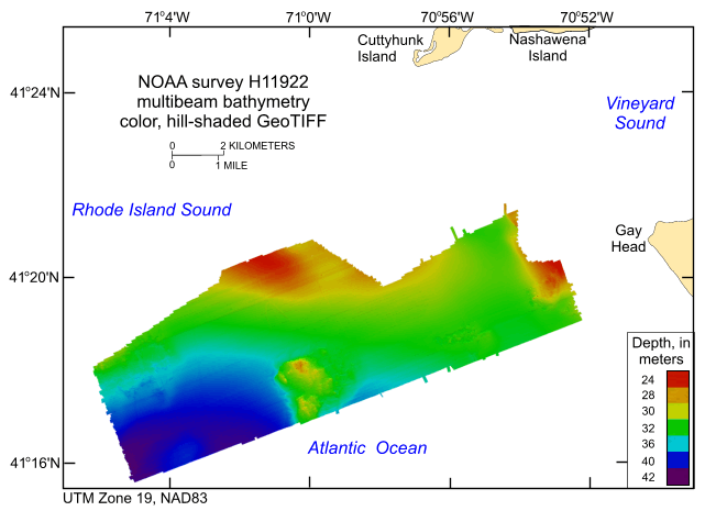
Figure 20. Digital terrain model (DTM) of the sea floor produced from multibeam bathymetry collected during National Oceanic and Atmospheric Administration survey H11922 west of Gay Head, Massachusetts, in eastern Rhode Island Sound. Image is sun-illuminated from the north and vertically exaggerated 5x. Hotter colors are shallower areas; cooler colors are deeper areas. See key for depth ranges.

Skip USGS links group

Accessibility FOIA Privacy Policies and Notices

Take Pride in America logo USAGov logo U.S. Department of the Interior | U.S. Geological Survey
End of USGS links group