Skip past header information
USGS - science for a changing world
NOAA Logo with link to NOAA Home Page.Massachusetts CZM Logo with link to MA CZM Home Page.  

U.S. Geological Survey Open-File Report 2011–1004

Sea-Floor Geology and Character of Eastern Rhode Island Sound West of Gay Head, Massachusetts


Skip past contents information

Title | List of Figures | Conversion Factors | Abstract | Introduction | Setting | Methods | Bathymetry | Sediment Distribution | Bottom Photography | GIS Data Catalog | Summary | Acknowledgments | References | Contacts


Figure 24. An image of bathymetric data showing winnowed bouldery sea floor.

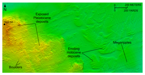
Figure 24. Detailed planar view of the bathymetric data collected during National Oceanic and Atmospheric Administration survey H11922 showing the gradual transition from winnowed bouldery sea floor to the surrounding Holocene deposits in the south-central part of the study area and the location of station 922-14. Note the presence of megaripples, and fingers of eroded Holocene deposits creating a valley and ridge type topography. Location of view is shown in figure 21.

Skip USGS links group

Accessibility FOIA Privacy Policies and Notices

Take Pride in America logo USAGov logo U.S. Department of the Interior | U.S. Geological Survey
End of USGS links group