Open-File Report 2011-1244
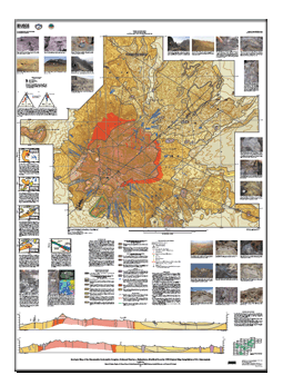
This map is a modified version of the Geological map of the Khanneshin carbonatite complex, scale 1:10,000, which was compiled by V.G. Cheremytsin in 1976. Scientists from the U.S. Geological Survey, in cooperation with the Afghan Geological Survey and the Task Force for Business and Stability Operations of the U.S. Department of Defense, studied the original map and also visited the field area in September 2009, August 2010, and February 2011. This modified map, which includes cross sections, illustrates the geologic structure of the Khanneshin carbonatite complex. The map reproduces the topology (contacts, faults, and so forth) of the original Soviet map and cross sections and includes modifications based on our examination of that map and a related report, and based on observations made during our field visits. (Refer to the References section in the Map PDF for complete citations of the original map and related report.) Elevations on the cross sections are derived from the original Soviet topography and may not match the newer topography used on the current map. We have attempted to translate the original Russian terminology and rock classification into modern English geologic usage as literally as possible without changing any genetic or process-oriented implications in the original descriptions. We also use the age designations from the original map. The unit colors on the map and cross sections differ from the colors shown on the original version. The units are colored according to the color and pattern scheme of the Commission for the Geological Map of the World (CGMW) (http://www.ccgm.org). |
First posted September 27, 2011 For additional information contact: Part or all of this report is presented in Portable Document Format (PDF); the latest version of Adobe Reader or similar software is required to view it. Download the latest version of Adobe Reader, free of charge. |
Tucker, R.D., Peters, S.G., Schulz, K.J., Renaud, K.M., Stettner, W.R., Masonic, L.M., and Packard, P.H., comps., 2011, Geologic map of the Khanneshin carbonatite complex, Helmand Province, Afghanistan, modified from the 1976 original map compilation of V.G. Cheremytsin: U.S. Geological Survey Open-File Report 2011–1244, one sheet, scale 1:10,000. Also available at https://pubs.usgs.gov/of/2011/1244/.

![]() U.S. Department of the Interior |
U.S. Geological Survey
U.S. Department of the Interior |
U.S. Geological Survey
URL: https://pubsdata.usgs.gov/pubs/of/2011/1244/
Page Contact Information: Contact USGS
Page Last Modified: Wednesday, 07-Dec-2016 23:58:21 EST


