 Introduction Introduction
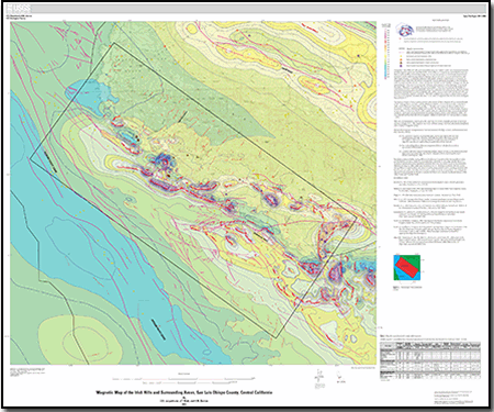
A magnetic map of the Irish Hills and surrounding areas was created as part of a cooperative research and development agreement with the Pacific Gas and Electric Company and is intended to promote further understanding of the areal geology and structure by serving as a basis for geophysical interpretations and by supporting geological mapping, mineral and water resource investigations, and other topical studies. Local spatial variations in the Earth's magnetic field (evident as anomalies on magnetic maps) reflect the distribution of magnetic minerals, primarily magnetite, in the underlying rocks. In many cases the volume content of magnetic minerals can be related to rock type, and abrupt spatial changes in the amount of magnetic minerals can be related to either lithologic or structural boundaries. Magnetic susceptibility measurements from the area indicate that bodies of serpentinite and other mafic and ultramafic rocks tend to produce the most intense magnetic anomalies, but such generalizations must be applied with caution because some sedimentary units also can produce measurable magnetic anomalies. Remanent magnetization does not appear to be a significant source for magnetic anomalies because it is an order of magnitude less than the induced magnetization.
The map is a mosaic of three separate surveys collected by (1) fixed-wing aircraft at a nominal height of 305 m, (2) by boat with the sensor at sea level, and (3) by helicopter. The helicopter survey was flown by New-Sense Geophysics in October 2009 along flight lines spaced 150-m apart and at a nominal terrain clearance of 50 to 100 m. Tie lines were flown 1,500-m apart. Data were adjusted for lag error and diurnal field variations. Further processing included microleveling using the tie lines and subtraction of the reference field defined by International Geomagnetic Reference Field (IGRF) 2005 extrapolated to August 1, 2008.
|
Files for viewing and printing:
- Map PDF (~48" x ~39", 22.1 MB)
-
This report is available only on the Web.
Part of this report is presented in Portable Document Format (PDF); the latest version of Adobe Reader or similar software is required to view it. Download the latest version of Adobe Reader, free of charge. |

