Open-File Report 2012–1183
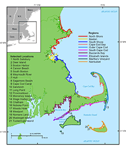
AbstractIdentifying the rates and trends associated with the position of the shoreline through time presents vital information on potential impacts these changes may have on coastal populations and infrastructure, and supports informed coastal management decisions. This report publishes the historical shoreline data used to assess the scale and timing of erosion and accretion along the Massachusetts coast from New Hampshire to Rhode Island including all of Cape Cod, Martha’s Vineyard, Nantucket and the Elizabeth Islands. This data is an update to the Massachusetts Office of Coastal Zone Management Shoreline Change Project. Shoreline positions from the past 164 years (1845 to 2009) were used to compute the shoreline change rates. These data include a combined length of 1,804 kilometers of new shoreline data derived from color orthophoto imagery collected in 2008 and 2009, and topographic lidar collected in 2007. These new shorelines have been added to previously published historic shoreline data from the Massachusetts Office of Coastal Zone Management and the U.S. Geological Survey. A detailed report containing a discussion of the shoreline change data presented here and a summary of the resulting rates is available and cited at the end of the Introduction section of this report. |
First posted September 6, 2013
For additional information contact: Part or all of this report is presented in Portable Document Format (PDF); the latest version of Adobe Reader or similar software is required to view it. Download the latest version of Adobe Reader, free of charge. |
Smith, T.L., Himmelstoss, E.A., and Thieler, E.R., 2013, Massachusetts shoreline change project—A GIS compilation of vector shorelines and associated shoreline change data for the 2013 update: U.S. Geological Survey Open-File Report 2012–1183, http://pubs.usgs.gov/of/2012/1183/.
Abstract
Introduction
Data Sources
Methods
Geospatial Data
Acknowledgments
References Cited

![]() U.S. Department of the Interior |
U.S. Geological Survey
U.S. Department of the Interior |
U.S. Geological Survey
URL: http://pubsdata.usgs.gov/pubs/of/2012/1183/index.html
Page Contact Information: GS Pubs Web Contact
Page Last Modified: Friday, 06-Sep-2013 11:36:10 EDT