H12023_MB2M_GEO.TIF: Color Shaded-Relief GeoTIFF Image Showing the 2-m Bathymetry Generated from National Oceanic and Atmospheric Administration (NOAA) Survey H12023 in Block Island Sound (Geographic, WGS84)

Metadata also available as - [Outline] - [Parseable text]

Frequently-anticipated questions:


What does this data set describe?

Title:
H12023_MB2M_GEO.TIF: Color Shaded-Relief GeoTIFF Image Showing the 2-m Bathymetry Generated from National Oceanic and Atmospheric Administration (NOAA) Survey H12023 in Block Island Sound (Geographic, WGS84)
Abstract:
The U.S. Geological Survey (USGS), in cooperation with the National Oceanic and Atmospheric Administration (NOAA), is producing detailed geologic maps of the coastal sea floor. Bathymetric and sidescan-sonar data, originally collected by NOAA for charting purposes, provide a fundamental framework for research and management activities along this part of Block Island Sound, show the composition and terrain of the seabed, and provide information on sediment transport and benthic habitat. During June 2012, bottom photographs and surficial sediment data were acquired as part of a ground-truth reconnaissance survey of this area. Interpretations were derived from the multibeam-echosounder, sidescan-sonar, sedimentary, and photographic data collected in Block Island Sound. For more information on the ground-truth survey see <http://woodshole.er.usgs.gov/operations/ia/public_ds_info.php?fa=2012-002-FA>.
  1. How should this data set be cited?

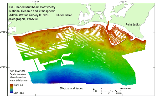
    National Oceanic and Atmospheric Administration, and U.S. Geological Survey, 2013, H12023_MB2M_GEO.TIF: Color Shaded-Relief GeoTIFF Image Showing the 2-m Bathymetry Generated from National Oceanic and Atmospheric Administration (NOAA) Survey H12023 in Block Island Sound (Geographic, WGS84): Open-File Report 2013-1003, U.S. Geological Survey, Coastal and Marine Geology Program, Woods Hole Coastal and Marine Science Center, Woods Hole, MA.

    Online Links:

    This is part of the following larger work.

    McMullen, K.Y., Poppe, L.J., Ackerman, S.D., Blackwood, D.S., Lewit, P.G., and Parker, C.E., 2013, Sea-floor geology in northeastern Block Island Sound, Rhode Island: Open-File Report 2013-1003, U.S. Geological Survey, Coastal and Marine Geology Program, Woods Hole Coastal and Marine Science Center, Woods Hole, MA.

    Online Links:

    Other_Citation_Details: DVD-ROM

  2. What geographic area does the data set cover?

    West_Bounding_Coordinate: -71.607167
    East_Bounding_Coordinate: -71.475183
    North_Bounding_Coordinate: 41.380240
    South_Bounding_Coordinate: 41.311455

  3. What does it look like?

    <http://pubs.usgs.gov/of/2013/1003/data/bathy/geotifs/geo/h12023_mb2m_geo.gif> (GIF)
    Thumbnail image of the GeoTIFF showing the 2-m color hill-shaded bathymetry collected during NOAA survey H12023 in geographic, WGS84

  4. Does the data set describe conditions during a particular time period?

    Beginning_Date: 24-Aug-2009
    Ending_Date: 22-Oct-2011
    Currentness_Reference: ground condition

  5. What is the general form of this data set?

    Geospatial_Data_Presentation_Form: remote-sensing image

  6. How does the data set represent geographic features?

    1. How are geographic features stored in the data set?

      This is a Raster data set. It contains the following raster data types:

      • Dimensions 3217 x 6172 x 1, type Pixel

    2. What coordinate system is used to represent geographic features?

      Horizontal positions are specified in geographic coordinates, that is, latitude and longitude. Latitudes are given to the nearest 0.000021. Longitudes are given to the nearest 0.000021. Latitude and longitude values are specified in Decimal degrees.

      The horizontal datum used is D_WGS_1984.
      The ellipsoid used is WGS_1984.
      The semi-major axis of the ellipsoid used is 6378137.000000.
      The flattening of the ellipsoid used is 1/298.257224.

  7. How does the data set describe geographic features?

    Entity_and_Attribute_Overview:
    There are no attributes associated with the GeoTIFF image. Pixel values convey RGB values of individual cells. Warmer colors (e.g. red) are shallower depths; cooler colors (blues and purples) are deeper. NODATA values are white (255-255-255).


Who produced the data set?

  1. Who are the originators of the data set? (may include formal authors, digital compilers, and editors)

  2. Who also contributed to the data set?

  3. To whom should users address questions about the data?

    U.S. Geological Survey
    c/o Katherine McMullen
    Field and Laboratory Technician
    384 Woods Hole Road
    Woods Hole, MA 02543-1598
    USA

    (508) 548-8700 x2277 (voice)
    (508) 457-2310 (FAX)
    kmcmullen@usgs.gov


Why was the data set created?

To release a color shaded-relief GeoTIFF of the 2-m bathymetry generated from NOAA survey H12023 in Block Island Sound in geographic, WGS84 coordinates.


How was the data set created?

  1. From what previous works were the data drawn?

    (source 1 of 1)
    National Ocean Survey, National Oceanic and Atmospheric Adminis, Unpublished Material, H12023 bathymetry.

    Type_of_Source_Media: disc
    Source_Contribution: Original processed multibeam bathymetric data.

  2. How were the data generated, processed, and modified?

    Date: 2011 (process 1 of 8)
    Bathymetric data were acquired in extended Triton data format (XTF) and recorded digitally through an ISIS data acquisition system. A RESON 7125, hull-mounted on the NOAA ship Thomas Jefferson and one 8.5-m launch and a RESON 8125 multibeam echosounder, mounted on another 8.5-m launch deployed from the NOAA ship Thomas Jefferson, were used to acquire the sounding data. All positioning and attitude were determined with Trimble DSM212L DGPS receivers and Applanix POS/MV Model 320 v.4 inertial navigation systems. The data were processed using CARIS HIPS (Hydrographic Image Processing System) software for quality control, and to incorporate sound velocity and tidal corrections. Sound velocity corrections were derived using frequent SEACAT CTD (conductivity-temperature-depth) profiles. Typically, a CTD cast was conducted every three to four hours of multibeam acquisition. Tidal zone corrections were calculated from data acquired at the Newport, Rhode Island, New London, Connecticut, and Montauk, New York tidal gauges. The vertical resolution of the multibeam data is approximately 0.5% of the water depth. The data were gridded to 2-m resolution and saved as a CARIS HIPS database. Vertical datum is mean lower low water; X and Y units are meters; UTM Zone 19, NAD83.

    Person who carried out this activity:

    National Oceanic and Atmospheric Administration
    c/o Jasper Schaer
    Field Operations Officer
    439 West York Street
    Norfolk, VA 23510
    USA

    (757) 441-6726 (voice)
    jasper.schaer@noaa.gov

    Data sources produced in this process:
    • CARIS HIPS database

    Date: 2012 (process 2 of 8)
    The H12023 CARIS HIPS base surface H12023_Combined_2m_CUBE_Deep_Final (fieldsheet H12023_Combined) was opened in CARIS HIPS/SIPS v7.0 and exported as a GeoTIFF image (24-bit, compressed format) using the CARIS HIPS Export Wizard. Sun illumination was from the north at 45 degrees above the horizon. Vertical exaggeration is 5x.

    Person who carried out this activity:

    National Oceanic and Atmospheric Administration
    c/o Gene Parker
    Hydrographer
    439 West York Street
    Norfolk, VA 23510
    USA

    (757) 441-6746 (voice)
    castle.e.parker@noaa.gov

    Data sources used in this process:
    • CARIS HIPS database

    Data sources produced in this process:

    • H12023_mb2m_utm.tif

    Date: 2012 (process 3 of 8)
    Created a world file from the GeoTIFF supplied by NOAA using GeoTIFF Examiner. This process step and all subsequent steps were performed by the same person, Katherine McMullen.

    Person who carried out this activity:

    Katherine McMullen
    U.S. Geological Survey
    Field and Laboratory Technician
    384 Woods Hole Road
    Woods Hole, MA 02543
    USA

    (508) 548-8700 x2277 (voice)
    (508) 457-2310 (FAX)
    kmcmullen@usgs.gov

    Data sources used in this process:
    • H12023_mb2m_utm.tif

    Data sources produced in this process:

    • H12023_mb2m_utm.tfw

    Date: 2012 (process 4 of 8)
    Reprojected dataset from UTM Zone 19, NAD 83 to geographic, WGS84 using ArcGIS Project Raster tool (ArcGIS 9.3) using geographic transformation 1 and remaining default settings.

    Data sources used in this process:

    • H12023_mb2m_utm.tif

    Data sources produced in this process:

    • H12023_mb2m_geo.tif

    Date: 2012 (process 5 of 8)
    Created a world file using GeoTIFF Examiner.

    Data sources used in this process:

    • H12023_mb2m_geo.tif

    Data sources produced in this process:

    • H12023_mb2m_geo.tfw

    Date: 2012 (process 6 of 8)
    Using Adobe Photoshop CS2, selected and filled triangles at outer margins of image (created when image was reprojected) with white using the paint bucket tool and saved without applying compression.

    Data sources used in this process:

    • H12023_mb2m_geo.tif

    Data sources produced in this process:

    • H12023_mb2m_geo.tif

    Date: 2012 (process 7 of 8)
    Used GeoTIFF Examiner to update the header of the TIFF to contain the georeferencing information from the world file, making the image a GeoTIFF.

    Data sources used in this process:

    • H12023_mb2m_geo.tif
    • H12023_mb2m_geo.tfw

    Data sources produced in this process:

    • H12023_mb2m_geo.tif

    Date: 2012 (process 8 of 8)
    Defined projection as Geographic, WGS84 using Define Projection tool in ArcGIS 9.3.

    Data sources used in this process:

    • H12023_mb2m_geo.tif

    Data sources produced in this process:

    • H12023_mb2m_geo.tif

  3. What similar or related data should the user be aware of?

    Smith, Shepard M. , 2009, H12023: Descriptive Report H12023, National Ocean Survey, National Oceanic and Atmospheric Administration, Atlantic Hydrographic Branch, Norfolk, VA.

    Online Links:

    McMullen, K.Y., Poppe, L.J., Haupt, T.A., and Crocker, J.M., 2009, Sidescan-sonar imagery and surficial geologic interpretations of the sea floor in western Rhode Island Sound: Open-File Report 2008-1181, U.S. Geological Survey, Coastal and Marine Geology Program, Woods Hole Coastal and Marine Science Center, Woods Hole, MA.

    Online Links:

    McMullen, K.Y., Poppe, L.J., Denny, J.F., Haupt, T.A., and Crocker, J.M., 2008, Sidescan-sonar imagery and surficial geologic interpretations of the sea floor in central Rhode Island Sound: Open-File Report 2007-1366, U.S. Geological Survey, Coastal and Marine Geology Program, Woods Hole Coastal and Marine Science Center, Woods Hole, MA.

    Online Links:

    Poppe, L.J., Danforth, W.W., McMullen, K.Y., Blankenship, M.A., Glomb, K.A., Wright, D.B., and Smith, S.M., 2012, Sea-floor character and sedimentary processes of Block Island Sound, offshore Rhode Island: Open-File Report 2012-1005, U.S. Geological Survey, Coastal and Marine Geology Program, Woods Hole Coastal and Marine Science Center, Woods Hole, MA.

    Online Links:

    McMullen, K.Y., Poppe, L.J., Ackerman, S.D., Blackwood, D.S., Schaer, J.D., Nadeau, M.A., and Wood, D.A., 2011, Surficial geology of the sea floor in central Rhode Island Sound southeast of Point Judith, Rhode Island: Open-File Report 2011-1005, U.S. Geological Survey, Coastal and Marine Geology Program, Woods Hole Coastal and Marine Science Center, Woods Hole, MA.

    Online Links:

    Other_Citation_Details: DVD-ROM


How reliable are the data; what problems remain in the data set?

  1. How well have the observations been checked?

  2. How accurate are the geographic locations?

    Navigation was by differential GPS using Trimble DSM212L DGPS receivers (accurate to <1m). CARIS HIPS was used to process bathymetry data including correcting for vessel offset.

  3. How accurate are the heights or depths?

    The vertical resolution of the bathymetry data is approximately 0.5% of the water depth. Although there are no depth attributes associated with the GeoTIFF image, pixel values convey RGB values of individual cells. Warmer colors (e.g. red) are shallower depths; cooler colors are deeper.

  4. Where are the gaps in the data? What is missing?

    All collected data were processed and used to produce this dataset.

  5. How consistent are the relationships among the observations, including topology?

    No additional checks for consistency were performed on this data.


How can someone get a copy of the data set?

Are there legal restrictions on access or use of the data?

Access_Constraints: None
Use_Constraints:
Data are not to be used for navigation purposes. Public domain data are freely redistributable with proper metadata and source attribution. Please recognize the National Oceanic and Atmospheric Administration (NOAA) and U.S. Geological Survey (USGS) as the originators of this information.

  1. Who distributes the data set? (Distributor 1 of 1)

    U.S. Geological Survey
    c/o Larry Poppe
    Geologist
    384 Woods Hole Road
    Woods Hole, MA 02543-1598
    USA

    (508) 548-8700 x2314 (voice)
    (508) 457-2310 (FAX)
    lpoppe@usgs.gov

  2. What's the catalog number I need to order this data set?

    Downloadable Data

  3. What legal disclaimers am I supposed to read?

    Neither the U.S. Government, the Department of the Interior, nor the USGS, nor the National Oceanic and Atmospheric Administration (NOAA), nor any of their employees, contractors, or subcontractors, make any warranty, express or implied, nor assume any legal liability or responsibility for the accuracy, completeness, or usefulness of any information, apparatus, product, or process disclosed, nor represent that its use would not infringe on privately owned rights. The act of distribution shall not constitute any such warranty, and no responsibility is assumed by the USGS or NOAA in the use of these data or related materials. Any use of trade, product, or firm names is for descriptive purposes only and does not imply endorsement by the U.S. Government.

  4. How can I download or order the data?

  5. What hardware or software do I need in order to use the data set?

    This image is available as a GeoTIFF image with an accompanying world file. To utilize this data, the user must have an image viewer, image processing or GIS software package capable of importing a GeoTIFF image. The user must have software capable of uncompressing archived zip files, such as WinZip or Pkware.


Who wrote the metadata?

Dates:
Last modified: 12-Jun-2013
Metadata author:
Katherine McMullen
U.S. Geological Survey
Sediment Lab Technician
384 Woods Hole Road
Woods Hole, MA 02543-1598
USA

(508) 548-8700 x2277 (voice)
(508) 457-2310 (FAX)
kmcmullen@usgs.gov

Metadata standard:
FGDC Content Standards for Digital Geospatial Metadata (FGDC-STD-001-1998)
Metadata extensions used:


Generated by mp version 2.8.25 on Wed Jun 12 08:20:22 2013