 Introduction Introduction
In 1994, the largest salt mine in North America, which had been in operation for more than 100 years, catastrophically flooded when the mine ceiling collapsed. In addition to causing the loss of the mine and the mineral resources it provided, this event formed sinkholes, caused widespread subsidence to land, caused structures to crack and subside, and changed stream flow and erosion patterns. Subsequent flooding of the mine drained overlying aquifers, changed the groundwater salinity distribution (rendering domestic wells unusable), and allowed locally present natural gas to enter dwellings through water wells. Investigations including exploratory drilling, hydrologic and water-quality monitoring, geologic and geophysical studies, and numerical simulation of groundwater flow, salinity, and subsidence have been effective tools in understanding the environmental consequences of the mine collapse and informing decisions about management of those consequences for the future.
Salt mines are generally dry, but are susceptible to leaks and can become flooded if groundwater from overlying aquifers or surface water finds a way downward into the mined cavity through hundreds of feet of rock. With its potential to flood the entire mine cavity, groundwater is a constant source of concern for mine operators. The problem is compounded by the viscous nature of salt and the fact that salt mines commonly lie beneath water-bearing aquifers. Salt (for example halite or potash) deforms and “creeps” into the mined openings over time spans that range from years to centuries. This movement of salt can destabilize the overlying rock layers and lead to their eventual sagging and collapse, creating permeable pathways for leakage of water and depressions or openings at land surface, such as sinkholes. Salt is also highly soluble in water; therefore, whenever water begins to flow into a salt mine, the channels through which it flows increase in diameter as the surrounding salt dissolves. Some mines leak at a slow rate for decades before a section of rock gives way, allowing what initially was a trickle of water to suddenly become a cascade and finally a torrent. Other mines become flooded and are destroyed when an errant drill hole punctures the mine ceiling, allowing water from overlying sources to flow into the mine. Either scenario can cause catastrophic flooding and permanent loss of the mine. Occasionally, a mine that has remained dry for a century will undergo a roof collapse that results in flooding.
|
First posted September 10, 2013
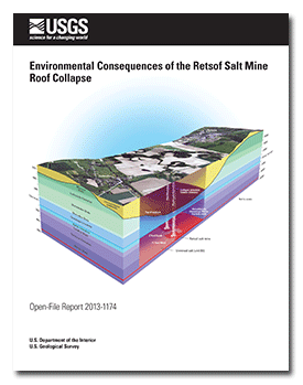
- Block diagram (fig 2) PDF (17.5 MB)
Perspective three-dimensional views showing the geologic setting and the unconsolidated sediments in the area of the Retsof salt mine in Livingston County, New York.
- Related reports:
Technical summary of studies by US Geological Survey concerning effects of salt-mine collapse
Simulation of brine and saline water migration from the flooded salt mine
Simulation of effects of salt-mine collapse on glacial aquifer system
- Animation - showing brine and saline water migration from the flooded salt mine
Part or all of this report is presented in Portable Document Format (PDF); the latest version of Adobe Reader or similar software is required to view it. Download the latest version of Adobe Reader, free of charge. |

