Open-File Report 2013–1221
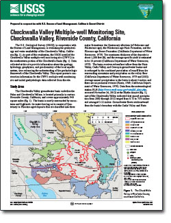
The U.S. Geological Survey (USGS), in cooperation with the Bureau of Land Management, is evaluating the geohydrology and water availability of the Chuckwalla Valley, California. As part of this evaluation, the USGS installed the Chuckwalla Valley multiple-well monitoring site (CWV1) in the southeastern portion of the Chuckwalla Basin. Data collected at this site provide information about the geology, hydrology, geophysics, and geochemistry of the local aquifer system, thus enhancing the understanding of the geohydrologic framework of the Chuckwalla Valley. This report presents construction information for the CWV1 multiple-well monitoring site and initial geohydrologic data collected from the site. |
First posted October 21, 2013 For additional information contact: Part or all of this report is presented in Portable Document Format (PDF); the latest version of Adobe Reader or similar software is required to view it. Download the latest version of Adobe Reader, free of charge. |
Everett, R.R., 2013, Chuckwalla Valley multiple-well monitoring site, Chuckwalla Valley, Riverside County, California: U.S. Geological Survey Open-File Report 2013–1221, 6 p.
Study Area
Well Completion
Geology at the CWV1 site
Hydrology
Geochemistry
Accessing Data
References

![]() U.S. Department of the Interior |
U.S. Geological Survey
U.S. Department of the Interior |
U.S. Geological Survey
URL: http://pubsdata.usgs.gov/pubs/of/2013/1221/index.html
Page Contact Information: GS Pubs Web Contact
Page Last Modified: Monday, 21-Oct-2013 15:44:35 EDT
