Open-File Report 2014-1040
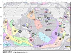
Polygons of Global Undersea Features for Geographic Searches

![]() U.S. Department of the Interior |
U.S. Geological Survey
U.S. Department of the Interior |
U.S. Geological Survey
URL: http://pubsdata.usgs.gov/pubs/of/2014/1040/ofr2014-1040-figures.html
Page Contact Information: GS Pubs Web Contact
Page Last Modified: Monday, 25-Jun-2018 10:15:58 EDT