Online Links:
Online Links:
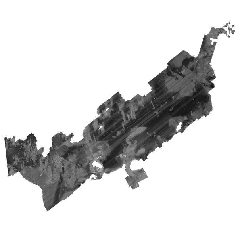
This backscatter intensity mosaic was created as a single continuous image of the acoustic reflectivity of the sea floor for Buzzards Bay. Generally, higher backscatter values (light tones) represent rock, boulders, cobbles, gravel, and coarse sand. Lower values (dark tones) usually represent fine sand and muddy sediment. These data in both this final form and at the input resolutions helped define the sediment texture and distribution maps presented as interpretive data layers in USGS OFR 2014-1220.
Online Links:
Online Links:
Online Links:
Online Links:
Online Links:
Online Links:
Online Links:
Online Links:
Are there legal restrictions on access or use of the data?
- Access_Constraints: None
- Use_Constraints:
- Public domain data from the U.S. Government are freely redistributable with proper metadata and source attribution. Please recognize the U.S. Geological Survey (USGS) as the source of this information.
Neither the U.S. Government, the Department of the Interior, nor the USGS, nor any of their employees, contractors, or subcontractors, make any warranty, express or implied, nor assume any legal liability or responsibility for the accuracy, completeness, or usefulness of any information, apparatus, product, or process disclosed, nor represent that its use would not infringe on privately owned rights. The act of distribution shall not constitute any such warranty, and no responsibility is assumed by the U.S. Geological Survey in the use of these data or related materials. Any use of trade, product, or firm names is for descriptive purposes only and does not imply endorsement by the U.S. Government
| Data format: | This WinZip v. 14.5 file contains a GeoTIFF image with a world file (and associated metadata) of backscatter data collected in Buzzards ay in format GeoTIFF (version PCI 2013) GeoTIFF image Size: 710 |
|---|---|
| Network links: |
https://pubs.usgs.gov/of/2014/1220/GIS_catalog/SourceData/BS_composite_1m.zip https://pubs.usgs.gov/of/2014/1220/ofr2014-1220-data_catalog.html https://dx.doi.org/10.3133/ofr20141220 |
The image contained in the zip file is available as a GeoTIFF with a world file. To utilize this data, the user must have an image viewer, or an image processing or GIS software package capable of importing a TIFF image.