2008CoreFieldDescriptions: PDF converted hand-written descriptions of 20 cores from offshore Puerto Rico and the U.S. Virgin Islands for cores collected by the U.S. Geological Survey in 2008.

Metadata also available as

Frequently-anticipated questions:


What does this data set describe?

Title:
2008CoreFieldDescriptions: PDF converted hand-written descriptions of 20 cores from offshore Puerto Rico and the U.S. Virgin Islands for cores collected by the U.S. Geological Survey in 2008.
Abstract:
In 2008, as a collaborative effort between Woods Hole Oceanographic Institution and the U.S. Geological Survey, 20 giant gravity cores were collected from areas surrounding Puerto Rico and the U.S. Virgin Islands. The regions sampled have had many large earthquake and landslide events, some of which are believed to have triggered tsunamis. The objective of this coring cruise, carried out aboard the National Oceanic and Atmospheric Administration research vessel Seward Johnson, was to determine the age of several substantial slope failures and seismite layers near Puerto Rico in an effort to map their temporal distribution. Data gathered from the cores collected in 2008 and 11 archive cores from the Lamont-Doherty Earth Observatory are included in this report. These data include lithologic logs, core summary sheets, x-ray fluorescence, wet-bulk density, magnetic susceptibility, grain-size analyses, radiographs, and radiocarbon age dates.
Supplemental_Information:
For more information on the USGS cruise, please see: <http://woodshole.er.usgs.gov/operations/ia/public_ds_info.php?fa=2008-008-FA>
  1. How should this data set be cited?

    U.S. Geological Survey, 2014, 2008CoreFieldDescriptions: PDF converted hand-written descriptions of 20 cores from offshore Puerto Rico and the U.S. Virgin Islands for cores collected by the U.S. Geological Survey in 2008.: Open-File Report 2014-1227, U.S. Geological Survey, Coastal and Marine Geology Program, Woods Hole Coastal and Marine Science Center, Woods Hole, MA.

    Online Links:

    This is part of the following larger work.

    Hoy, Shannon K. , Chaytor, Jason D. , and Uri S. ten Brink, 2014, Core Data From Offshore Puerto Rico and the U.S. Virgin Islands: Open-File Report 2014-1227, U.S. Geological Survey, Reston, VA.

    Online Links:

  2. What geographic area does the data set cover?

    West_Bounding_Coordinate: -67.0795
    East_Bounding_Coordinate: -64.82283
    North_Bounding_Coordinate: 19.17558
    South_Bounding_Coordinate: 17.552930

  3. What does it look like?

    <https://pubs.usgs.gov/of/2014/1227/data/2-CoreFieldDescriptions/2008CoreFieldDescription.jpg> (JPEG)
    Example of Core Field Description from core SJ8-5GGC

  4. Does the data set describe conditions during a particular time period?

    Beginning_Date: 18-Mar-2008
    Ending_Date: 24-Mar-2008
    Currentness_Reference: ground condition; cores collected in 2008

  5. What is the general form of this data set?

  6. How does the data set represent geographic features?

    1. How are geographic features stored in the data set?

    2. What coordinate system is used to represent geographic features?

  7. How does the data set describe geographic features?

    Entity_and_Attribute_Overview:
    Although the core descriptions are not geospatial, they are related to the core locations which are available in the PRcore_locations shapefile available from <https://pubs.usgs.gov/of/2014/1227/1-CoreLocations/PRcore_locations.zip>


Who produced the data set?

  1. Who are the originators of the data set? (may include formal authors, digital compilers, and editors)

  2. Who also contributed to the data set?

  3. To whom should users address questions about the data?

    Jason D. Chaytor
    U.S. Geological Survey
    Research Geologist
    384 Woods Hole Road
    Woods Hole, MA 02543-1598

    (508) 548-8700 x2351 (voice)
    (508) 457-2310 (FAX)
    jchaytor@usgs.gov


Why was the data set created?

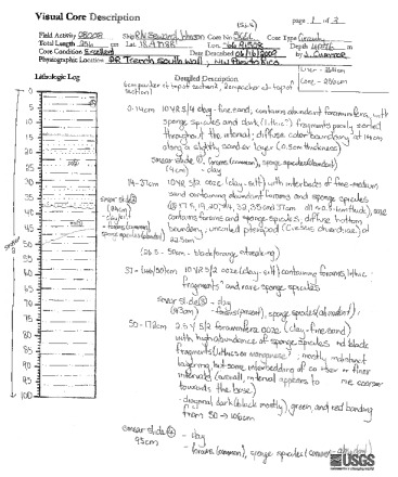
This data set contains field descriptions (PDF) for the 20 cores collected in 2008 on the R/V Seward Johnson during field activity 2008-008-FA.


How was the data set created?

  1. From what previous works were the data drawn?

    PR Bathymetry (source 1 of 2)
    Andrews, B.D., ten Brink, U.S., Danforth, W.W., Chaytor, J.D., Granja Burna, J.L., Llanes Estrada, P., and Carbo-Gorosabel, A., in prep, Bathymetric Terrain Model of Puerto Rico Trench and the Northeast Caribbean Region: Marine Geological Investigations: Open File Report, U.S. Geological Survey, Reston, VA.

    Type_of_Source_Media: Open File Report
    Source_Contribution:
    The 50 meter grid was used for depth information in the sample area

    GGC (source 2 of 2)
    Hoy, Shannon K. , Chaytor, Jason D. , and Uri S. ten Brink, 2014, Core data from offshore Puerto Rico and the U.S. Virgin Islands: Open File Report 2014-1227, U.S. Geological Survey, Reston, VA.

    Online Links:

    Type_of_Source_Media: physical samples
    Source_Contribution:
    The gravity cores collected during U.S. Geological Survey field activity 2008-008-FA. The Woods Hole Oceanographic Giant Gravity Corer (GGC) was used to collect the 20 cores in 2008. The gravity corer is a large diameter (10 centimeter) sampler that collects cores up to 6.5 meters in length. During field activity 2008-008-FA the corer was not rigged with liner longer than approximately 3 meters. Although cores were attempted at 40 core sites, core was recovered at only 20 sites. Seven additional sites yielded only samples (bagged) from the core catcher or cutting head. Of the 20 successful cores, three also have cutter/catcher bag samples.

  2. How were the data generated, processed, and modified?

    Date: 2009 (process 1 of 2)
    Jason D. Chaytor examined the cores at the U.S. Geological Survey in Woods Hole at a centimeter scale. Hand-written observations were made of sediment type, notable bioturbation, shells, texture, color, and stiffness. See the individual PDF's for a complete listing of the observations.

    Person who carried out this activity:

    Jason D. Chaytor
    U.S. Geological Survey
    Research Geologist
    384 Woods Hole Road
    Woods Hole, MA 02543-1598

    (508) 548-8700 x2351 (voice)
    (508) 457-2310 (FAX)
    jchaytor@usgs.gov

    Data sources used in this process:
    • GGC

    Date: 2013 (process 2 of 2)
    Hand-written field descriptions were converted to PDF format via scanning.

    Person who carried out this activity:

    Shannnon K. Hoy
    U.S. Geological Survey
    Research Associate
    384 Woods Hole Road
    Woods Hole, MA 02543-1598

    (508) 548-8700 x2297 (voice)
    (508) 457-2310 (FAX)
    shoy@usgs.gov

  3. What similar or related data should the user be aware of?


How reliable are the data; what problems remain in the data set?

  1. How well have the observations been checked?

    Files were double checked that filename matched the core that was described.

  2. How accurate are the geographic locations?

  3. How accurate are the heights or depths?

  4. Where are the gaps in the data? What is missing?

    This report contains all of the field descriptions from the 2008 SJ8 cores. There were 20 cores requiring field descriptions: 5GGC, 7GGC, 8GGC, 9GGC, 10GGC, 12GGC, 13GGC, 17GGC, 18GGC, 20GGC, 21GGC, 22GGC, 23GGC, 24GGC, 28GGC, 31GGC, 33GGC, 34GGC, 38GGC, and 40GGC. There are missing numbers due to failed core attempts or a site that only yielded a bag samples.

  5. How consistent are the relationships among the observations, including topology?

    The naming convention is: CoreName_field. The core name is the core number paired with the abbreviation GGC, which stands for giant gravity corer (##GGC). Field stands for field description.


How can someone get a copy of the data set?

Are there legal restrictions on access or use of the data?

Access_Constraints: None
Use_Constraints:
The Public domain data from the U.S. Government are freely redistributable with proper metadata and source attribution. Please recognize the U.S. Geological Survey as the originator of the dataset.

  1. Who distributes the data set? (Distributor 1 of 1)

    Jason D. Chaytor
    U.S. Geological Survey
    Research Geologist
    384 Woods Hole Road
    Woods Hole, MA 02543-1598

    (508) 548-8700 x2351 (voice)
    (508) 457-2310 (FAX)
    jchaytor@usgs.gov

  2. What's the catalog number I need to order this data set?

    Downloadable Data

  3. What legal disclaimers am I supposed to read?

    Neither the U.S. Government, the Department of the Interior, nor the USGS, nor any of their employees, contractors, or subcontractors, make any warranty, express or implied, nor assume any legal liability or responsibility for the accuracy, completeness, or usefulness of any information, apparatus, product or process disclosed, nor represent that its use would not infringe on privately owned rights. The act of distribution shall not constitute any such warranty, and no responsibility is assumed by the USGS in the use of these data or related materials. Any use of trade, product, or firm names is for descriptive purposes only and does not imply endorsement by the U.S. Government.

  4. How can I download or order the data?

  5. What hardware or software do I need in order to use the data set?

    The user must be able unzip a WinZip18 compressed file as well as view PDFs


Who wrote the metadata?

Dates:
Last modified: 28-Mar-2014
Metadata author:
U.S. Geological Survey
c/o Shannon K. Hoy
Research Associate II
384 Woods Hole Road
Woods Hole, MA 02543-1598
United States

(508) 548-8700 x2297 (voice)
(508) 457-2310 (FAX)
shoy@usgs.gov

Metadata standard:
FGDC Content Standards for Digital Geospatial Metadata (FGDC-STD-001-1998)


Generated by mp version 2.9.6 on Tue Oct 28 11:01:41 2014