Open-File Report 2015–1042
AbstractThe flooding that occurred in north-central Colorado in 2013 was some of the most destructive in the state’s history. Following a summer of drought and wildfires, a wet weather system stalled over the Front Range area from Fort Collins in the north to Colorado Springs in the south, including the cities of Lyons and Longmont. This weather system produced rainfall amounts that greatly exceeded historical highs. The Colorado Office of Emergency Management reported at least eight deaths. More than 11,000 people were evacuated from their homes, and the flooding caused an estimated $2 billion dollars in damages. On September 14, 2013, President Barack Obama issued a major disaster declaration for 15 Colorado counties affected by the severe weather and related damage. To support local, State, and Federal disaster response coordination efforts in Colorado, the U.S. Geological Survey (USGS) developed a geospatial product to identify surface-water cover from Lyons to western Longmont. This information was derived from September 13, 2013 WorldView-2 multispectral imagery at a spatial resolution of 3 meters (m). These data were orthocorrected and pan-sharpened. Three spectral indices (NDVI, NDWI, and NDTI) that were computed from this processed imagery were used to help determine the extent of the surface-water cover. The result was converted to a vector format. This surface-water cover dataset was created as a timely representation of post-flood ground conditions to support response efforts. This dataset and all processed imagery and derived products were uploaded to the USGS Hazards Data Distribution System (HDDS) website (http://hddsexplorer.usgs.gov/uplift/hdds/) for distribution to those responding to the flood event. |
First posted March 23, 2015 For additional information, contact: Part or all of this report is presented in Portable Document Format (PDF). For best results viewing and printing PDF documents, it is recommended that you download the documents to your computer and open them with Adobe Reader. PDF documents opened from your browser may not display or print as intended. Download the latest version of Adobe Reader, free of charge. More information about viewing, downloading, and printing report files can be found here. |
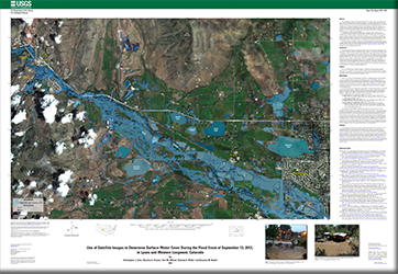
Cole, C.J., Friesen, B.A., Wilson, E.M., Wilds, S.R., and Noble, S.M., 2013, Use of satellite images to determine surface-water cover during the flood event of September 13, 2013, in Lyons and western Longmont, Colorado: U.S. Geological Survey Open-File Report 2015–1042, 1 sheet, scale 1:15,000, https://dx.doi.org/10.3133/ofr20151042/.
ISSN 2331–1258 (online)