
U.S. Geological
Survey
Open-File Report 99-349
[Approved for publication 7/16/99]
Mapping the Glacial Geology of the Central Great Lakes Region in Three Dimensions -- A Model for State-Federal Cooperation
By Richard C. Berg, Ned K. Bleuer, Berwyn E. Jones, Kevin A. Kincare, Richard R. Pavey, and Byron D. Stone
INTRODUCTION
The Central Great Lakes region, comprising Illinois, Indiana, Michigan, and Ohio, is one of the Nation's most productive and economically important regions. It contains about one-seventh of the Nation's population, has one-fifth of the Nation's heavy industry, and produces one-third of the Nation's corn and soybeans.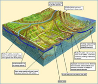 It is the transportation crossroads of North America and accounts for over half of the $180-$200 billion in annual trade between the United States and Canada. The continued economic growth and well-being of the region and the security of its population and ecology are related to fundamental issues involving land resources, geologic hazards, and environmental protection. In the past, conflicting demands on land, water, mineral, and biological resources and inadequate information concerning the relationships among these resources resulted in decisions that were not compatible with sustainable development of the region and the continued high quality of life for future generations.
Planners need to evaluate complex and competing public-policy options for managing water, land, and biological resources; they must ensure economic growth, meet the needs of an increasing population, assess hazards, and manage the environment in a sustainable manner. The State Geological Surveys of Illinois, Indiana, Michigan, and Ohio and the U.S. Geological Survey (USGS) receive many requests from local, State, and Federal planners and officials for geologic information. Thick and complex layers of glacial and related sediments blanket the bedrock of these States: a three-dimensional understanding of these deposits is critical to making informed resource-management and other planning decisions.
At two recent forums (in Indianapolis, March 1997, and Columbus, Ohio, February 1999), more than 200 attendees from more than 60 local, State, and Federal agencies provided a clear message. They need three-dimensional geologic information to use in making decisions on the following issues:
Download a PDF version of this report [2.9MB]
Download Adobe Acrobat Reader version 4.0 for free
[Note: This report can be viewed with version 3.0 of Acrobat Reader]
This report is preliminary and has not been reviewed for conformity with U.S. Geological Survey editorial standards or with the North American Stratigraphic Code. Any use of trade, firm, or product names is for descriptive purposes only and does not imply endorsement by the U.S. Government
For questions about the content of this report, contact Byron Stone at [email protected].
Return to 1999 Open-File Reports [Online]
This page is https://pubs.usgs.gov/pdf/of/ofr99349/
Maintained by: Eastern Publications Group Web Team
Last modified: 8/9/00 (krw)