
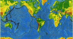
This map shows the Earth's physiographic features, the current movements of its major tectonic plates, and the locations of its volcanoes, earthquakes, and impact craters. The use of color and shaded relief helps the reader to identify significant features of the land surface and the ocean floor. Over 1,500 volcanoes active during the past 10,000 years are plotted on the map in four age categories. The locations (epicenters) of over 24,000 earthquakes, largely from 1960 through 1990, are plotted in three magnitude categories and in two depth ranges.
The map is intended as a teaching aid for classroom use and as a general reference for research. It was published in 1994.
This is a cover page. To go to the actual document, click on the above title or image. The document is in PDF format (3.3 MB), consisting of 8 pages of text and figures and the map itself as page 9. You will need Adobe Adobe Reader to view and print. Click here to download Adobe Reader.
The paper map can be ordered from:
USGS Information Services
Box 25286
Denver, CO 80225
Fax: 303-202-4693
or call 1-888-ASK-USGS.