Central Earth Surface Processes
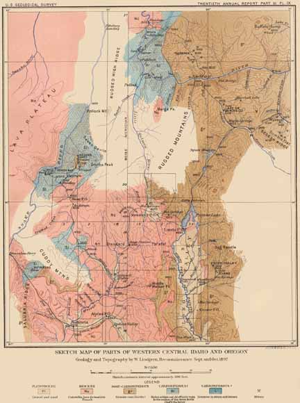
Sketch map of parts of west-central Idaho and eastern Oregon. This is one of the classic early geological maps of this region by Waldemar Lindgren and was published in the U.S. Geological Survey’s Twentieth Annual Report in 1900. See chapter 1 for more information.
The papers in this volume describe petrologic, structural, and geochemical studies related to geographic areas adjacent to and including the Salmon River suture zone. We therefore start this volume by defining and giving a general description of that suture zone.
The western margin of the North American continent was the setting for complex terrane accretion and large-scale terrane translation during Late Cretaceous and Eocene time. In western Idaho, the boundary that separates the Paleozoic-Mesozoic accreted oceanic, island-arc rocks on the west from Precambrian continental metamorphic and sedimentary rocks on the east is called the Salmon River suture zone (SRSZ). Readers will note that the term Salmon River suture zone is used in the title of this volume and in the text of several of the papers and the term western Idaho suture zone is used in several other papers in this volume. Both terms refer to the same geologic feature and reflect historical usage and custom; thus no attempt has been made by the editors to impose or demand a single term by the various authors of this volume.
The suture zone is marked by strong lithologic and chemical differences. Rocks adjacent to the suture zone are characterized by high-grade metamorphism and much structural deformation. In addition, the zone was the locus of emplacement of plutons ranging in composition from tonalite to monzogranite during and after the final stages of accretion of the oceanic terrane to the North American continent.
The contents of this paper consists of these seven chapters:
![]() Download this report as a 210-page PDF file (45 MB). (
Download this report as a 210-page PDF file (45 MB). (![]() )
)
For questions about the content of this report, contact Mel Kuntz
Suggested citation and version history
Download a current version of Adobe Reader for free
| Help
| PDF help
| Western reports main page | Western Professional Papers |
| Geologic Division | Centeral Earth Surface Processes
|
This report is also available in print from:
USGS Information Services, Box 25286,
Federal Center, Denver, CO 80225
telephone: 888 ASK-USGS; e-mail: infoservices@usgs.gov

![]() U.S. Department of the Interior | U.S. Geological Survey
U.S. Department of the Interior | U.S. Geological Survey
URL: https://pubs.usgs.gov/pp/2007/1738/
Page Contact Information: Michael Diggles
Page Last Modified: October 25, 2007