FISC - St. Petersburg
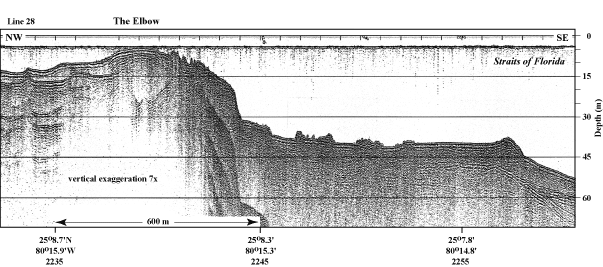
Figure 10. Example of the high-quality seismic profiles (1997) used in this project. This profile crossed the shelf margin and upper-slope terrace at The Elbow (upper Keys, Fig. 6C, Tile 1). Note presence of a backreef trough in the bedrock (deep "W" shape in reflection of bedrock surface under the name of the reef). The trough has been filled with Holocene reefs and sediments and has no topographic expression in the present-day sea floor. Reflections in a seismic record represent a change in acoustic (sound-wave) impedance across contacts between rock layers having different acoustic properties. In other words, seismic reflections indicate the presence of subsurface rock surfaces or stratigraphic horizons within the rock record. In this case, the stratigraphic horizon is the unconformity between Pleistocene and Holocene limestones (see Fig. 7B). Latitude and longitude in degrees and decimal minutes based on GPS coordinates. Hours (military time) below coordinates serve as navigational correlation points along seismic line. (Figure modified from Lidz et al., 2003).
|
Can't see the printable PDF version? Get the free Adobe Acrobat® Reader. |
