FISC - St. Petersburg
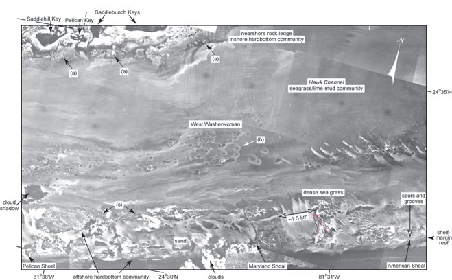
Figure 11. Example of the high-quality aerial photos (1975) used in this study. This photomosaic shows benthic features from the south edge of the Saddlebunch Keys (lower Keys, Fig. 6C, Tile 6) across the shelf to the shelf-margin reef. Note areas of patch reefs with their characteristic sand haloes (a) on a nearshore rock ledge, (b) in Hawk Channel at West Washerwoman, and (c) in grassy areas along the outer shelf. Note elongate zone of storm-transported reef rubble behind American Shoal (red dashed lines).
|
Can't see the printable PDF version? Get the free Adobe Acrobat® Reader. |

![]() U.S. Department of the Interior |
U.S. Geological Survey
U.S. Department of the Interior |
U.S. Geological Survey
URL: [disc] /pubs/pp/2007/1751/professional-paper/figures/fig11.html
Page Contact Information: Feedback
Page Last Modified: December 01, 2016 @ 04:11 PM (JSS)
