FISC - St. Petersburg
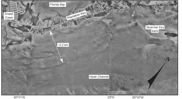
Figure 13. Sample photomosaic (1975) shows the nearshore rock ledge that lines the seaward side of the Florida Keys (modified from Lidz et al., 2003). Area shown is in the upper Keys. A tidal delta at Snake Creek and a muddy bank at Tavernier Key cover parts of the rock ledge. Note that the ledge is much wider than the adjacent island, Plantation Key (Fig. 6A,Tile 2). The inner part of the ledge is covered with thin sands. The outer part is generally bare rock.
|
Can't see the printable PDF version? Get the free Adobe Acrobat® Reader. |

![]() U.S. Department of the Interior |
U.S. Geological Survey
U.S. Department of the Interior |
U.S. Geological Survey
URL: [disc] /pubs/pp/2007/1751/professional-paper/figures/fig13.html
Page Contact Information: Feedback
Page Last Modified: December 01, 2016 @ 04:11 PM (JSS)
