FISC - St. Petersburg
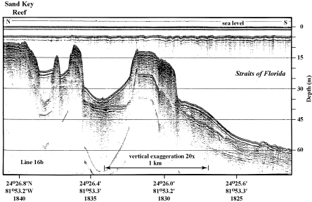
Figure 18. Sample seismic profile (1997) shows three of four tracts of outlier reefs off Sand Key Reef in the lower Keys (modified from Lidz et al., 1991; Fig. 7B, Tile 7/8). The largest outlier, cored and dated, developed at the seaward edge of an upper-slope terrace. Note the seismic reflection representing the gently sloping, nearly flat terrace surface between the largest outlier reefs. Latitude and longitude in degrees and decimal minutes based on GPS coordinates. Hours (military time) below coordinates serve as navigational correlation points along seismic line.
|
Can't see the printable PDF version? Get the free Adobe Acrobat® Reader. |

![]() U.S. Department of the Interior |
U.S. Geological Survey
U.S. Department of the Interior |
U.S. Geological Survey
URL: [disc] /pubs/pp/2007/1751/professional-paper/figures/fig18.html
Page Contact Information: Feedback
Page Last Modified: December 01, 2016 @ 04:11 PM (JSS)
