FISC - St. Petersburg
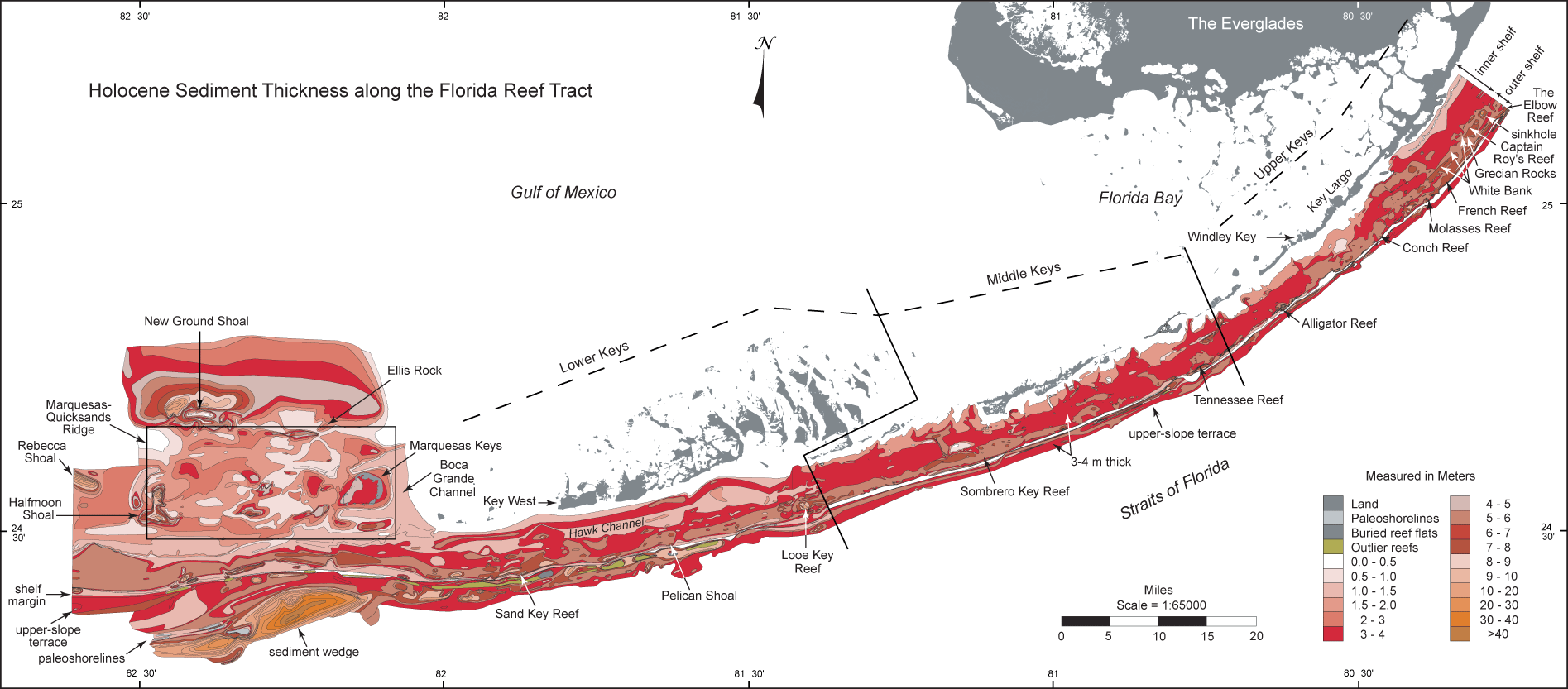
Sediment Thickness map: USGS geophysical data were combined with selected analogous data of Enos (1977; see Data Integration section) to produce an updated regional isopach map that shows contoured thickness of Holocene carbonates from the northern Florida Keys to west of The Quicksands. (From Lidz et al., 2003). Reef data are based on drill cores. Contours are in meters. Dogleg and diagonal lines divide upper, middle, and lower Keys.
Colors represent different thicknesses ranging from bare bedrock (white) to thinnest (pale pinks) to thicker (dark reds) to thickest (rust). White area at shelf margin denotes seaward sediment-free side of a massive discontinuous Pleistocene coral reef. This fossil reef marks the shelf margin at the 30-m depth contour. An upper-slope terrace lies at the toe of this reef in 30 to 40 m of water. Note areas of thinnest coverage (pale pinks) generally correspond to areas of highest bedrock elevations, such as on the Marquesas-Quicksands ridge (in the large black rectangle).
Sediments are generally ~3 to 4 m thick shelf-wide, indicating offshelf transport in the deeper southwestern area. The open-marine environment there is subject to stronger currents than the more restricted northeastern marine setting. The thickest shelf accumulations (~27-30 m) occur in a backreef trough behind the shelf margin, where both reef and trough are present. Thicker sediments (>55 m) are known to fill an outer-shelf sinkhole located off north Key Largo (Fig. 6C; Shinn et al., 1996). The thickest (>40 m) sediment buildup contoured on the map occurs on the upper slope southwest of the Marquesas Keys in 80 to 190 m of water.
The isopach map shows sites and types of localized sedimentary processes: accumulation in enclosed bedrock lows (north of New Ground Shoal and in sinkhole off Key Largo) and behind rock barriers (east of Halfmoon Shoal), and offshelf transport (sediment wedge southwest of the Marquesas Keys). Deep water around the Marquesas-Quicksands ridge and strong currents in Boca Grande Channel indicate that ridge sands form in place. Both maps show the location of NOAA's newly named Captain Roy's Reef off north Key Largo and the generally margin-parallel nature of Pleistocene and Holocene geomorphic trends seaward of the keys.
|
Can't see the printable PDF version? Get the free Adobe Acrobat® Reader. |

![]() U.S. Department of the Interior |
U.S. Geological Survey
U.S. Department of the Interior |
U.S. Geological Survey
URL: [disc] /pubs/pp/2007/1751/professional-paper/figures/sed-thickness.html
Page Contact Information: Feedback
Page Last Modified: December 01, 2016 @ 04:11 PM (JSS)
