FISC - St. Petersburg
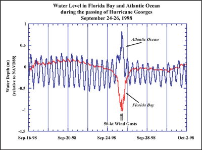
Figure 26. Plot shows surface-water level at well clusters in Florida Bay and the Atlantic Ocean during passage of Hurricane Georges, September 24-26, 1998 (from Reich et al., 2002). Bay-water level dropped ~1 m and the ocean level rose ~0.5 m. The storm surge occurred during a low tide, minimizing flooding of the low-lying keys (highest natural elevation in the keys is ~5.5 m; Lidz and Shinn, 1991). Water-level data are referenced to the North American Vertical Datum of 1988 (NAVD88).
|
Can't see the printable PDF version? Get the free Adobe Acrobat® Reader. |

![]() U.S. Department of the Interior |
U.S. Geological Survey
U.S. Department of the Interior |
U.S. Geological Survey
URL: [disc] /pubs/pp/2007/1751/professional-paper/tile1/figures/fig26.html
Page Contact Information: Feedback
Page Last Modified: December 01, 2016 @ 04:12 PM (JSS)
