FISC - St. Petersburg
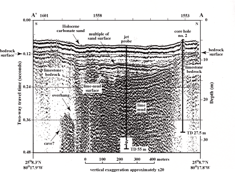
Figure 29. Seismic profile across sinkhole shows geology and sedimentology of the setting (from Shinn et al., 1996). A sediment-filled cave or overhang is present under the left (south) rim. Note opaque seismic signature in sinkhole sediments, a characteristic of gas-saturated sediments. Sediments in core hole no. 2 showed the mud is saturated with methane gas (Shinn et al., 1996). Core hole no. 2 penetrated 27.4 m of marine lime mud capped by a thin (< 5-m-thick) layer of carbonate sand. A jet probe penetrated 55 m of muddy sediment without hitting the bedrock floor. The 55-m depth is 61 m below present sea level. Latitude and longitude in degrees and decimal minutes based on GPS coordinates. Hours (military time) above ticks at top serve as navigational correlation points along seismic line. TD = total depth.
|
Can't see the printable PDF version? Get the free Adobe Acrobat® Reader. |

![]() U.S. Department of the Interior |
U.S. Geological Survey
U.S. Department of the Interior |
U.S. Geological Survey
URL: [disc] /pubs/pp/2007/1751/professional-paper/tile1/figures/fig29.html
Page Contact Information: Feedback
Page Last Modified: December 01, 2016 @ 04:12 PM (JSS)
