FISC - St. Petersburg
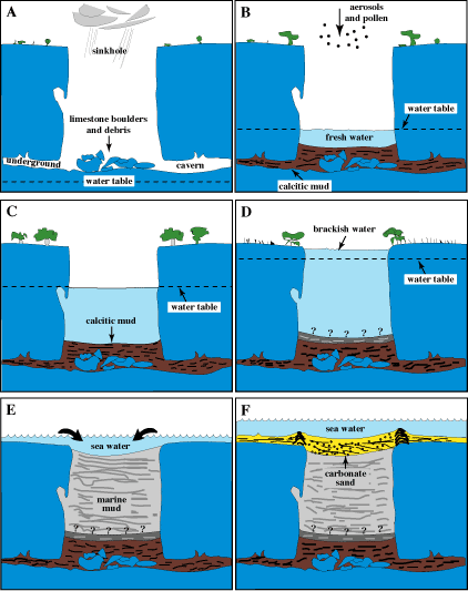
Figure 30. Model shows inferred depositional history of sediments in sinkhole (not to scale; modified from Shinn et al., 1996). (A) Sinkhole as it might have appeared ~15 ka with sea level 100 m or more below present level. Note collapsed boulders and overhang that developed above the freshwater table. (B) Sinkhole after rise of freshwater table in response to rising sea level. A shallow pond and calcite mud cover the bottom. (C) Sinkhole after continued sea-level rise. (D) Sinkhole after sea level had reached a position sufficiently high to create brackish-water conditions in the hole. Question marks indicate mud depth is unknown. (E) Initial flooding of sinkhole about 6 ka and introduction of marine-carbonate mud. (F) Sinkhole as it appears today, filled with mud and capped with carbonate sand derived from bordering coral accumulations.
|
Can't see the printable PDF version? Get the free Adobe Acrobat® Reader. |

![]() U.S. Department of the Interior |
U.S. Geological Survey
U.S. Department of the Interior |
U.S. Geological Survey
URL: [disc] /pubs/pp/2007/1751/professional-paper/tile1/figures/fig30.html
Page Contact Information: Feedback
Page Last Modified: December 01, 2016 @ 04:12 PM (JSS)
