FISC - St. Petersburg
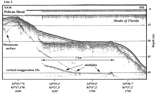
Figure 38. Seismic profile (1989) shows Pleistocene bedrock geology in the area of Pelican Shoal (from Lidz et al., 2003; Fig. 6C, Tile 6, lower Keys). Note wide, flat, upper-slope terrace with an elevated ridge at the seaward edge. This profile was used as the 'generic' surface on which evolutionary models of the shelf margin were based. Also note evidence of an old shoreline in Holocene sediment wedge at landward side of terrace. Horizontally bedded layers overlying inclined layers were probably eroded and redeposited in a tidal zone (Lidz et al., 2003). 'Multiples' are an artifact common in seismic-reflection data. These reflections replicate those of existing, overlying, geologic surfaces and should not be regarded as representing any subsurface stratigraphic horizon. Latitude and longitude in degrees and decimal minutes based on GPS coordinates. Hours (military time) below coordinates serve as navigational correlation points along seismic line.
|
Can't see the printable PDF version? Get the free Adobe Acrobat® Reader. |

![]() U.S. Department of the Interior |
U.S. Geological Survey
U.S. Department of the Interior |
U.S. Geological Survey
URL: [disc] /pubs/pp/2007/1751/professional-paper/tile1/figures/fig38.html
Page Contact Information: Feedback
Page Last Modified: December 01, 2016 @ 04:12 PM (JSS)
