FISC - St. Petersburg
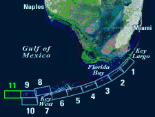
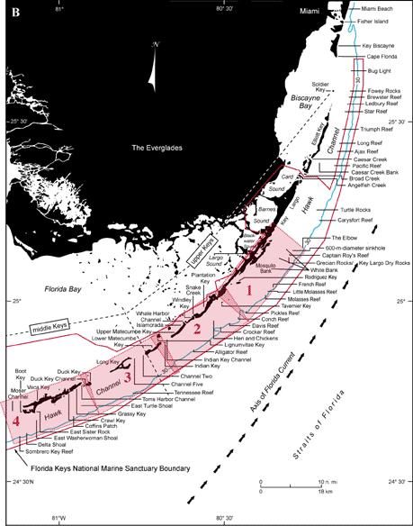
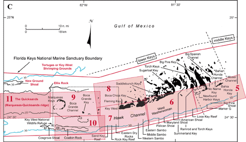
Figure 132. (A) Landsat satellite image of south Florida shows individual tile boundaries (blue rectangles) of this regional study in the Florida Keys National Marine Sanctuary. Tile 11 is highlighted. (B) Index map shows locations of named reefs and shoals in the upper Keys and northeastern middle Keys, delineated by dashed lines. Red rectangles show geographic boundaries of Tiles 1, 2, 3, and 4. (C) Contiguous southwestern part of index map shows named reefs and shoals in the westernmost middle Keys and lower Keys (dashed lines). Red rectangles show geographic boundaries of Tiles 5, 6, 7, 8, 9, 10, and 11, with Tile 11 and nearby geographic sites discussed highlighted. Halfmoon and Rebecca Shoals and an unnamed channel lie off the left side of the map. Black-dot rectangle shows area of Key West National Wildlife Refuge. Sanctuary boundary is in red; shelf-margin contour is in blue. Contours are in meters.
|
Can't see the printable PDF version? Get the free Adobe Acrobat® Reader. |

![]() U.S. Department of the Interior |
U.S. Geological Survey
U.S. Department of the Interior |
U.S. Geological Survey
URL: [disc] /pubs/pp/2007/1751/professional-paper/tile11/figures/fig132.html
Page Contact Information: Feedback
Page Last Modified: December 01, 2016 @ 04:13 PM (JSS)
