FISC - St. Petersburg
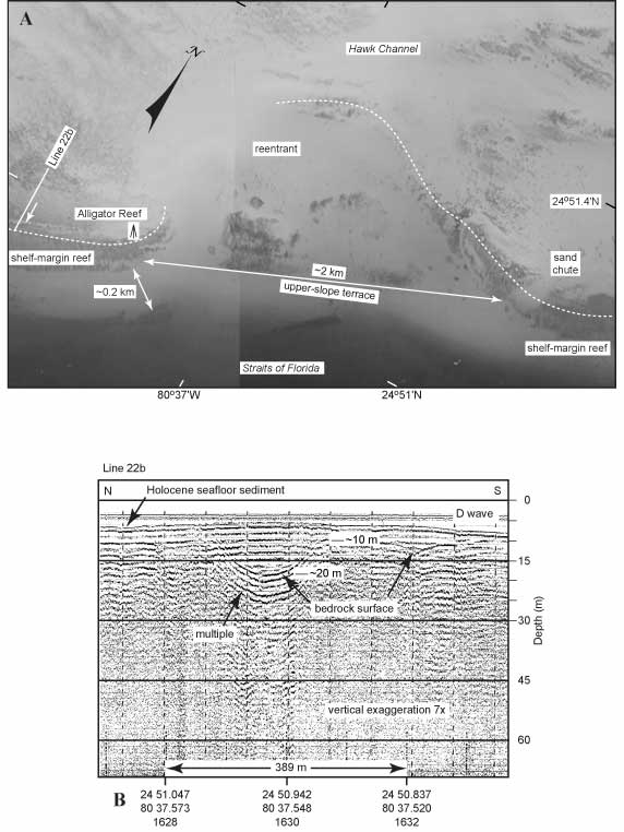
Figure 49. (A) Aerial photo (1991) shows the discontinuity of the shelf-margin reef, here due to a basin-like reentrant in the area of Alligator Reef, located ~11 km southwest of Davis Reef (modified from Lidz et al., 2003; Figs. 42B, 48B). Note concavity of the shelf-margin reef (white dotted line) and narrow width of the upper-slope terrace in front of the reentrant. 'Tripod' symbol shows location of Alligator Reef Light. Diagonal labeled 'Line 22b' west of tripod indicates approximate location of seismic profile shown in (B). Arrow next to Line 22b diagonal points to a margin-parallel line of sand behind the shelf-edge reef. (B) Seismic profile (1997) shows that the line of sand represents a sediment-filled, trough-like bedrock depression (from Lidz et al., 2003). Linearity of the line of sediment in (A) and its orientation normal to the seismic line indicates the image of the depression in this profile is probably its true shape. D wave = direct arrival (not a geologic surface). Holocene = the most recent 10 ka. 'Multiples' are an artifact common in seismic-reflection data. These reflections replicate those of existing, overlying, geologic surfaces and should not be regarded as representing any subsurface stratigraphic horizon. Latitude and longitude in degrees and decimal minutes based on GPS coordinates. Hours (military time) below coordinates serve as navigational correlation points along seismic line.
|
Can't see the printable PDF version? Get the free Adobe Acrobat® Reader. |
