FISC - St. Petersburg
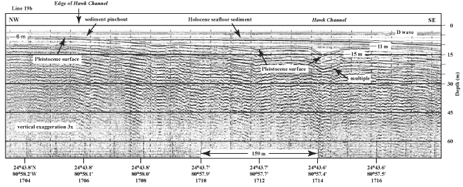
Figure 70. Bedrock depression (at right) southwest of Toms Harbor and Duck Key Channels (middle Keys, Fig. 68B) may represent extensions of one of those channels (from Lidz et al., 2003). Note sediment pinchout (at left) against smooth bare rock surface under Hawk Channel. D wave = direct arrival (not a geologic feature). 'Multiples' are an artifact common in seismic-reflection data. These reflections replicate those of existing, overlying, geologic surfaces and should not be regarded as representing any subsurface stratigraphic horizon. Latitude and longitude in degrees and decimal minutes based on GPS coordinates. Hours (military time) below coordinates serve as navigational correlation points along seismic line.
|
Can't see the printable PDF version? Get the free Adobe Acrobat® Reader. |

![]() U.S. Department of the Interior |
U.S. Geological Survey
U.S. Department of the Interior |
U.S. Geological Survey
URL: [disc] /pubs/pp/2007/1751/professional-paper/tile4/figures/fig70.html
Page Contact Information: Feedback
Page Last Modified: December 01, 2016 @ 04:13 PM (JSS)
