FISC - St. Petersburg
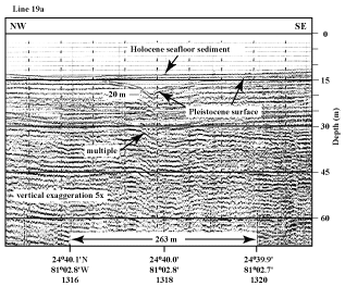
Figure 72. V-shaped depression in seismic profile from just east of East Washerwoman Shoal (middle Keys, Fig. 68B) may be the true image of a geologic feature with a southeastward trend (from Lidz et al., 2003). 'Multiples' are an artifact common in seismic-reflection data. These reflections replicate those of existing, overlying, geologic surfaces and should not be regarded as representing any subsurface stratigraphic horizon. The multiple indicated in this profile mimics the reflection of the Pleistocene bedrock surface. Latitude and longitude in degrees and decimal minutes based on GPS coordinates. Hours (military time) below coordinates serve as navigational correlation points along seismic line.
|
Can't see the printable PDF version? Get the free Adobe Acrobat® Reader. |

![]() U.S. Department of the Interior |
U.S. Geological Survey
U.S. Department of the Interior |
U.S. Geological Survey
URL: [disc] /pubs/pp/2007/1751/professional-paper/tile4/figures/fig72.html
Page Contact Information: Feedback
Page Last Modified: December 01, 2016 @ 04:13 PM (JSS)
