FISC - St. Petersburg
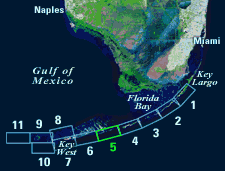
Figure 77. (A) Landsat satellite image of south Florida shows individual tile boundaries (blue rectangles) of this regional study in the Florida Keys National Marine Sanctuary. Tile 5 is highlighted. (B) Index map shows locations of named reefs and shoals in the upper Keys and northeastern middle Keys, delineated by dashed lines. Most named reefs and shoals were once historic islands. Red rectangles show geographic boundaries of Tiles 1, 2, 3, and 4. (C) Contiguous part of index map shows westernmost part of middle Keys and the lower Keys, delineated by dashed lines. Note the difference in island orientation. The upper and middle Keys are composed of the Pleistocene Key Largo Limestone coral reef. The lower Keys consist of oolitic tidal bars of the same age known as the Miami Limestone. Both rock formations accumulated during a stand of sea level at ~125 ka that was higher, perhaps by 10.7 m, than sea level is today. Red numbered rectangle denotes geographic boundaries of Tile 5 with its geographic sites highlighted. Sanctuary boundary is in red; shelf-margin contour is in blue. Contours are in meters.
|
Can't see the printable PDF version? Get the free Adobe Acrobat® Reader. |


