FISC - St. Petersburg
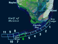
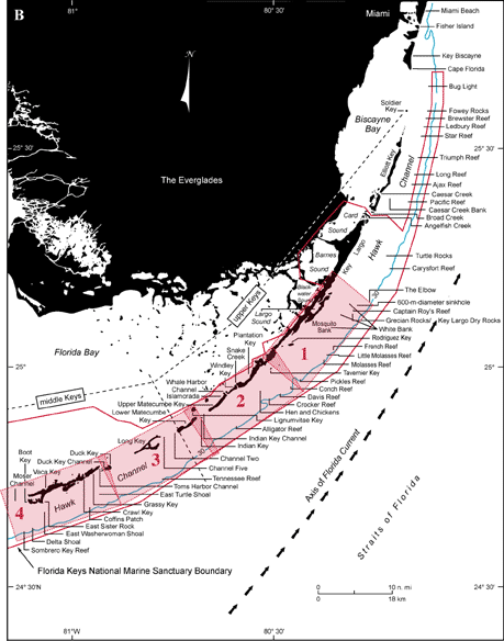
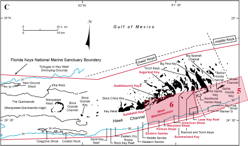
Figure 86. (A) Landsat satellite image of south Florida shows individual tile boundaries (blue rectangles) of this regional study in the Florida Keys National Marine Sanctuary. Tile 6 is highlighted. (B) Index map shows locations of named reefs and shoals in the upper Keys and northeastern middle Keys, delineated by dashed lines. Red rectangles show geographic boundaries of Tiles 1, 2, 3, and 4. (C) Contiguous part of index map shows westernmost part of middle Keys and the lower Keys (dashed lines). Red rectangles show geographic boundaries of Tiles 5 and 6, with Tile 6 and its geographic sites highlighted. Note the boundary of Looe Key National Marine Sanctuary (parallelogram at shelf margin) lies within the boundary of the Florida Keys National Marine Sanctuary (red line). Shelf-margin contour is in blue. Contours are in meters.
|
Can't see the printable PDF version? Get the free Adobe Acrobat® Reader. |

![]() U.S. Department of the Interior |
U.S. Geological Survey
U.S. Department of the Interior |
U.S. Geological Survey
URL: [disc] /pubs/pp/2007/1751/professional-paper/tile6/figures/fig86.html
Page Contact Information: Feedback
Page Last Modified: December 01, 2016 @ 04:14 PM (JSS)
