FISC - St. Petersburg
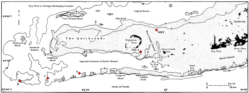
Figure 117. Generalized bathymetric map of Marquesas Keys and reef tract area west of Key West, Florida, shows locations of shallow (water depth 5-23 m) wells drilled between 1959 and 1962 (Table 9, after Dustan et al., 1991). Site D/E-1 represents two adjacent wells on a seagrass/gorgonian hardbottom 2 km southeast of the Marquesas (Table 10, after Dustan et al., 1991). Well 826Y was drilled on limestone bedrock 7 km northeast of the Marquesas. Well A was drilled from a jackup rig on coral bottom. Well C was drilled on sandy bottom, and well B, a few kilometers west of C, was drilled on a coral knoll. Well symbols are standard industry symbols for dry wells but are colored red for easy detection in this figure. Stippled pattern represents shallow submerged shelf.
|
Can't see the printable PDF version? Get the free Adobe Acrobat® Reader. |

![]() U.S. Department of the Interior |
U.S. Geological Survey
U.S. Department of the Interior |
U.S. Geological Survey
URL: [disc] /pubs/pp/2007/1751/professional-paper/tile9-10/figures/fig117.html
Page Contact Information: Feedback
Page Last Modified: December 01, 2016 @ 04:15 PM (JSS)
