FISC - St. Petersburg
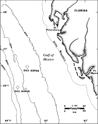
Figure 118. Bathymetric map off west-central Florida shows locations of deep (water depth 53-70 m) wells drilled in 1981 and 1986 (from Dustan et al., 1991; Table 9). Well symbols are standard industry symbols for dry wells. Both wells were drilled into limestone bedrock that was covered with a veneer of sand (Table 10).
|
Can't see the printable PDF version? Get the free Adobe Acrobat® Reader. |

![]() U.S. Department of the Interior |
U.S. Geological Survey
U.S. Department of the Interior |
U.S. Geological Survey
URL: [disc] /pubs/pp/2007/1751/professional-paper/tile9-10/figures/fig118.html
Page Contact Information: Feedback
Page Last Modified: December 01, 2016 @ 04:15 PM (JSS)
