FISC - St. Petersburg
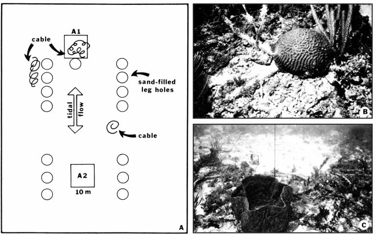
Figure 124. Well site A (from Dustan et al., 1991). (A) Diagram shows location of drill-rig footprints, census quadrats A1 and A2, tidal-flow directions, and distribution of debris that consisted mainly of discarded cable. Footprints were 4.5 m in diameter. Quadrat A-1 was down current, adjacent to sand hole around well bore, and included cable debris. Control quadrat A-2 contained no debris, was also down current on a reversed tide, and would have been under the rig platform, where organisms would have been subject to both drill effluents and shade. Bottom was flat. (B) Brain coral grew on intersection of two pieces of cable within quadrat A-1. Cable diameter is 5 cm. (C) Large barrel sponge grew on cable debris in quadrat A-1. View is toward circular sand-filled hole in background that conceals buried well bore. Video camera lies in sand hole. Vertical black line attached to piece of cable was tied to marker buoy.
|
Can't see the printable PDF version? Get the free Adobe Acrobat® Reader. |

![]() U.S. Department of the Interior |
U.S. Geological Survey
U.S. Department of the Interior |
U.S. Geological Survey
URL: [disc] /pubs/pp/2007/1751/professional-paper/tile9-10/figures/fig124.html
Page Contact Information: Feedback
Page Last Modified: December 01, 2016 @ 04:15 PM (JSS)
