
CONTRIBUTIONS TO THE GEOLOGY OF KENTUCKY
Loess in the Jackson Purchase region, as described by Olive (1980), consists of windblown silts assigned to three Pleistocene formations separated by unconformities marked by buried soils. The formations are the Peoria Loess (Woodfordian Substage of Wisconsinan), the Roxana Silt (Altonian Substage of Wisconsinan), and the Loveland Loess (Illinoian). The Peoria Loess is characteristically pale yellowish gray and is as much as 65 ft thick along the Mississippi River. The Roxana Silt is reddish brown and contains lenses of sand in the lower part; it is as much as 20 ft, but generally is less than 5 ft thick. The Loveland Loess is grayish orange and less than 10 ft thick; it has been recognized only in small areas west of Paducah. The windblown silt was probably derived from glacial outwash in the Ohio and Missisippi Valleys to the north and west. Blankets of loess occur elsewhere in Kentucky, generally along the Ohio River, but have not been mapped systematically and are not shown separately on the geologic map.
High-level fluvial deposits.High-level fluvial deposits, shown as a dot-pattern overprint on sheets I and 2 of the geologic map, occur along the Kentucky, Ohio, Licking, and Green Rivers. A small number of deposits, intended to be shown along the Licking River on sheet 3, were inadvertently removed in the printing process.
The high-level fluvial deposits shown on the geologic map, and described here, are shown by a number of
informal names on the geologic quadrangle maps, particularly those completed early in the mapping
program. Such names include fluvial deposits, terrace deposits, continental deposits, and gravel deposits.
The unit includes generally unconsolidated sediments of Pleistocene and probably Pliocene age that occur
some hundreds of feet above Holocene river deposits.
The most extensive and thickest high-level fluvial deposits occur along the Kentucky River, as shown on
sheet 2 of the geologic map. These deposits, as much as 100 ft thick, are mapped as high as 400 ft above
present river level. Unmapped scattered river gravels have been found even higher. They are composed of
sand, silt, clay, and gravel. The sand is generally fine grained, yellowish to reddish brown, and quartzose;
the silt and clay are commonly light brown or light gray. The gravel consists of rounded quartz and
quartzite pebbles, cobbles, and boulders as much as 2 ft long and includes minor amounts of chert; quartz
geodes are locally abundant. In some places, deposits are cemented by limonite.
High-level fluvial deposits are, for the most part, composed of material derived from Mississippian and Pennsylvanian rocks of south-central Kentucky, augmented in places by locally derived clasts from older strata. They represent the remnants of dissected terrace deposits and channel deposits of abandoned river segments. Over part of the area, these deposits are referred to as the "Irvine Formation" or informally as the "Irvine gravel." High-level deposits along the Ohio River northeast of the mouth of the Kentucky River at Carrollton have been shown by Swadley (1971,1974) to mark the course of the north-flowing preglacial Kentucky River.
The Licking River also has extensive high-level fluvial deposits extending from its mouth at Covington southeastward to near Morehead. These deposits resemble those along the Kentucky River, but the maximum clast size is smaller, deposits are not as thick, and geodes are lacking. The northernmost high level deposits of the Licking River include fine-grained lacustrine sediments apparently deposited during glacial ponding. The high-level fluvial deposits of the Licking River, as shown on sheet 2 of the map, have been described in detail by Luft (1980), who also presents an interpretation of the drainage evolution in this area.
Scattered high-level fluvial deposits occur along the Green River north and northeast of Bowling Green, as shown on sheet 1 of the geologic map. These deposits contain a high percentage of chert pebbles, commonly containing distinctive fossils, which are derived principally from Mississippian rocks exposed in the Green River watershed.
Glacial deposits (Qg).--Glacial deposits are shown along and near the Ohio River Valley on all three sheets of the geologic map. Glacial deposits are thickest and most extensive in north-central Kentucky (sheet 2), where they reach an aggregate thickness of several hundred feet. The unit consists chiefly of outwash, till, and lacustrine deposits. These deposits mantle the preglacial landscape and indicate the sequential advance and retreat of glacial ice in north-central Kentucky. In north-central Kentucky, Ohio, and Indiana, glacial deposits choked or obliterated old drainage systems and glacial meltwater eroded new channels beyond the ice margins. These changes resulted in permanent modifications of several major drainages, including the establishment of much of the present-day Ohio River (for example, see Swadley, 1980).
During the mapping program, portrayal of glacial deposits was variable, especially in western Kentucky. Because of inconsistent practices, glacial sediments (mainly outwash) have been combined with alluvium west of Cloverport, Breckinridge County, on sheet 1 of the geologic map. Between Cloverport and Louisville, areas shown as glacial deposits were originally mapped as older alluvium, lacustrine deposits, and terrace deposits. At Louisville and upriver, areas shown as glacial deposits on the State map were generally mapped as glacial outwash, lacustrine deposits, eolian sand, and glacial drift on the quadrangle maps. Exposures of drift were shown only by outcrop symbols in many places, and many of these localities have been combined and enlarged for the State map.
Glacial outwash has been mapped along the Ohio River Valley from Louisville to Vanceburg (Lewis County, Ky.). It is composed of sand, gravel, silt, and clay, with minor amounts of organic material locally. The sand consists of yellowish- to reddish-gray, very fine to coarse, subangular to well-rounded quartz with minor carbonate and chert. The sand is generally well sorted, and sand beds are commonly crossbedded. Gravel is brownish to reddish gray and consists mostly of well-rounded clasts as much as 4 in across; it is poorly to well sorted. Gravel beds are commonly crossbedded or have cut-and-fill structures. Gravels are composed mainly of clasts of carbonate rocks, chert, quartz, igneous and metamorphic rocks, and minor amounts of coal. The silt and clay are yellowish to olive gray and generally occur as lenses and interbeds in sand and gravel. The outwash forms sequences as thick as 200 ft. It is generally leached of carbonate components in the uppermost few feet, and is locally cemented with calcite or limonite at lower levels. On quadrangle maps, outwash was generally assigned to the Wisconsinan, Illinoian, and pre-Illinoian stages, mainly on the basis of terrace surface elevation and degree of weathering. Outwash of Wisconsinan age is most widespread and occurs at the lowest elevations. Glacial deposits shown on sheet 1, from Louisville westward to Cloverport, as well as unmapped glacial material included in alluvium (Oa) farther west, are also probably outwash of Wisconsinan age.
Glacial drift has been mapped only along the Ohio River upstream from Louisville (fig. 14) and is not as extensive or as thick as the outwash. Most of the deposits mapped as drift are till, but the deposits include various amounts of outwash, kame, and lacustrine deposits. The tills generally consist of gray, calcareous sandy and silty clay with angular pebbles of chert and rounded pebbles, cobbles, and boulders of quartz, quartzite, chert, and igneous and metamorphic rocks, including basalt, granite, diorite, gneiss, and schist. The till has no bedding and is unsorted, but it locally contains lenses or beds of outwash sand and gravel. The till is locally cemented with secondary calcite. Weathered horizons commonly have abundant limonite pellets or calcite concretions. Glacial drift deposits of different ages, which are as much as 100 ft thick, are distinguished by their degree of weathering (especially leaching of calcite) and their topographic position. Older drift is generally found in preglacial drainage valleys above 665 ft elevation. Exposures of older drift locally exhibit abundant stratified sand. Younger drift is assigned to the Illinoian glacial stage, the older to pre-Illinoian, within which Ray (1974) interpreted both Kansan and Nebraskan deposits. Well-preserved wood in Illinoian drift near Augusta, Bracken County, Ky., has been radiocarbon dated as greater than 40,000 years old (Outerbridge and others, 1973). No till of Wisconsinan age has been found in Kentucky.
Thick outwash deposits in the Ohio River Valley clammed tributaries to the south, and lacustrine sediments were deposited in the ponded water. These lacustrine deposits are as much as 140 ft thick and consist of laminated to thin-bedded, commonly calcareous, clayey silt and silty clay. Interbeds of fine sand at the downstream margins of the deposits are interpreted as interfingering glacial outwash. Lacustrine sediments are not extensive, except for a large area southeast of Louisville. In many places, small areas of lacustrine deposits are included with alluvium on the geologic map. Most lacustrine deposits are Wisconsinan in age, but some are probably Illinoian.
Loess composed mainly of well-sorted silt and eolian deposits of very fine to medium quartzose sand in blankets, ridges, and mounds as much as 70 ft thick are locally included in glacial deposits. Loess forms a thin surficial cover over many areas, especially in western Kentucky, that are shown as Paleozoic bedrock. Thick deposits of loess, already described, occur in the Jackson Purchase.
Alluvium (Qa).--Alluvium occurs throughout Kentucky and is shown along most of the larger streams
and tributaries on all three map sheets. It is particularly extensive along the Ohio River and its tributaries in
western Kentucky and the Jackson Purchase (sheet 1). As shown on this map, alluvium also includes
sediments mapped on the geologic quadrangle maps as (low) terrace and floodplain deposits, and in
western Kentucky as outwash deposits. Small areas of low-lying glacial deposits, such as lacustrine and
eolian sediments, are also included locally. Alluvium consists of boulders, cobbles, pellets, sand, silt, and clay
in various proportions; it is as much as 200 ft thick along major rivers. Most alluvium is Holocene, but some
is late Pleistocene. Charcoal from alluvium near Maysville, Ky., yielded a radiocarbon age of 9,010 ± 300
years (Gibbons and Weiss, 1972).
Colluvium, although extensive on many slopes, was not generally mapped and is not included on the State geologic map. Although colluvium is commonly thin and ubiquitous, locally it is thick, complex, and extensively weathered. These deposits span significant periods of the Quaternary. The oldest colluvium may be late Tertiary and is graded to the preglacial drainage systems recorded by high-level terrace deposits.
Glacial deposits have been related to the Pleistocene glacial stages of North America. They are correlated on the basis of degree of weathering, topographic position, elevation, and the occurrence of unconformities or paleosols between successive deposits. Glacial drift in north-central Kentucky, and glacial erratics scattered over much of the northern and western parts of the State (Leverett, 1929, fig. 3), indicate the presence of glacial ice during the Illinoian and older stages. Ray (1974) has identified drift deposits of Kansan and Nebraskan ages in northern Kentucky. Wisconsin glaciers did not reach Kentucky, and deposits of this stage are represented by outwash and related sediments. Figure 14 shows the southern boundary of glacial drift as shown on sheets 2 and 3 of the geologic map, and areas of Illinoian and older drift as reported by Ray (1974, pl. 1).
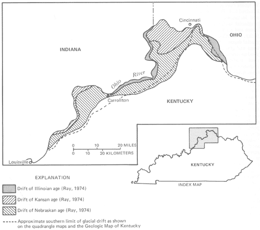
FIGURE 14.--Generalized map of glacial drift in Kentucky. |
PREVIOUS || Return to STRATIGRAPHY