Skip Links

USGS - science for a changing world

Professional Paper 1386–A

Cryosphere Note 3- Figure 2

Return to Home

Return to figure gallery

Select image for high resolution and Save to download
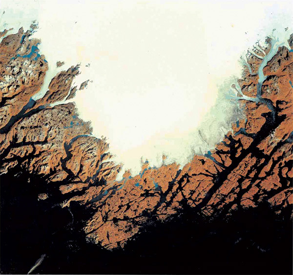
Figure 3-2.–Landsat 1 MSS digitally enhanced false-color composite image of the south slope of the Greenland ice sheet northwest of Julianehåb (Qaqortoq), South Greenland on 13 September 1980. The image shows the well-de ned edge of the Inland Ice which spreads over the lowlands of South Greenland toward the outer coast. In some areas, the snowline is clearly visible. The marginal areas of the Greenland ice sheet have undergone severe thinning during the late 20th century and early 21st century.

Figure 3–2. Landsat 1 MSS digitally enhanced false-color composite image of the south slope of the Greenland ice sheet northwest of Julianehåb (Qaqortoq), South Greenland on 13 September 1980. The image shows the well-defined edge of the Inland Ice which spreads over the lowlands of South Greenland toward the outer coast. In some areas, the snowline is clearly visible. The marginal areas of the Greenland ice sheet have undergone severe thinning during the late 20th century and early 21st century.


Accessibility FOIA Privacy Policies and Notices

Take Pride in America logo USA.gov logo U.S. Department of the Interior | U.S. Geological Survey
URL: http://pubsdata.usgs.gov/pubs/pp/p1386a/notes-fig3-2.html
Page Contact Information: GS Pubs Web Contact
Page Last Modified: Thursday, 01-Dec-2016 16:26:25 EST