Select image for high resolution and Save to download

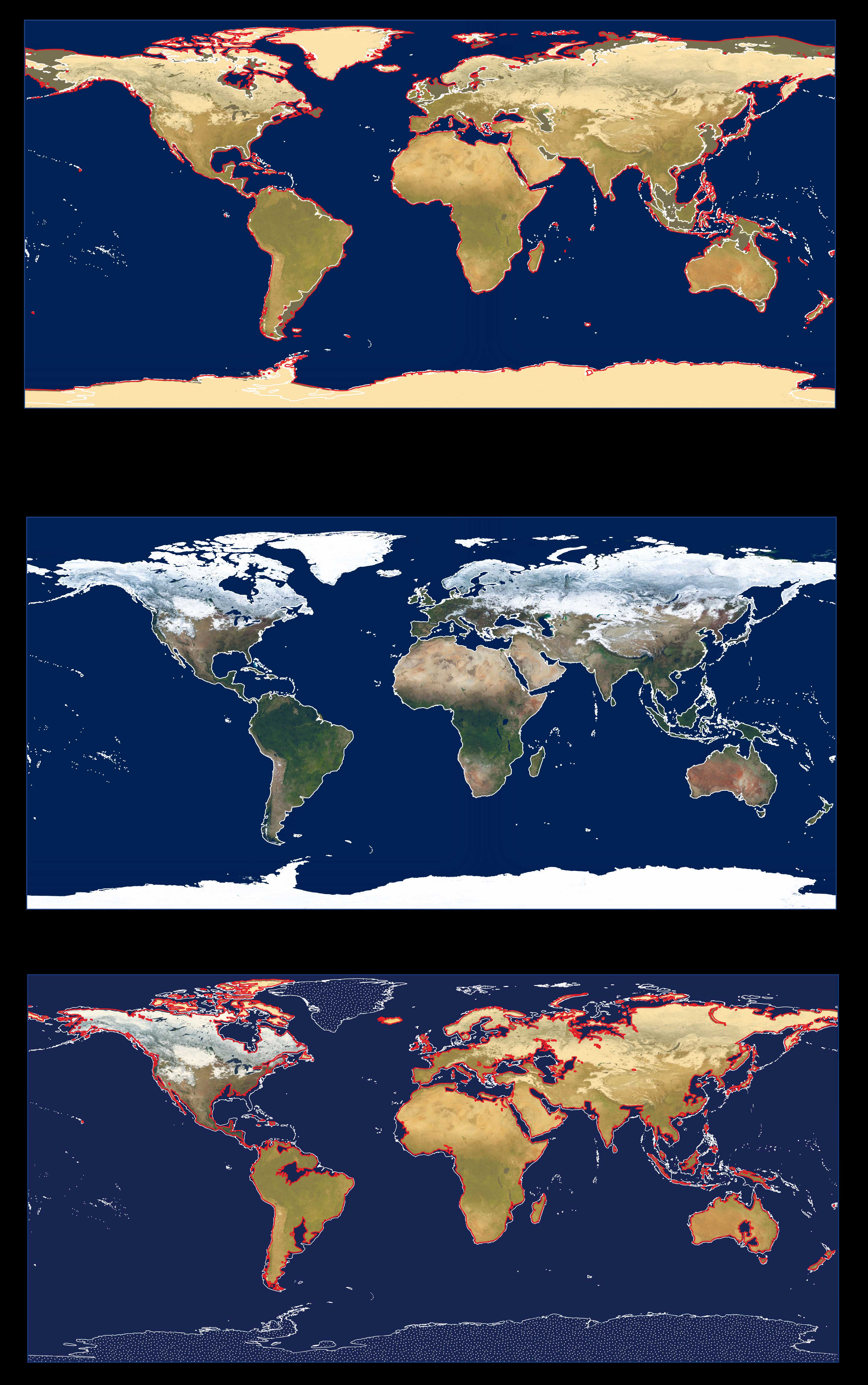
Earth’s Coastlines Approximately 20,000 Years before Present Sea level 20,000 years ago was lower by about 125 meters (about 410 feet) than it is
today. The Earth’s coastlines therefore extended farther into the oceans than they extend today (2009). The older coastline was drawn from data from The University of California at San Diego’s TOPEX/Poseidon Shuttle Radar Topography Mission (SRTM) 30 PLUS archive combined with a bathymetric dataset. Geologists drew outlines (in red) of the older coastlines over a modified version of the 2004 MODerate-resolution Imaging Spectroradiometer (MODIS) image-mosaic map of global snow cover. Snow cover (and glaciers) shown as white on the center graphic is shown here as a pale yellow color. The 2004 MODIS images were acquired by NASA’s Terra satellite. Present-day coastlines are delineated in white.
Earth’s Present-Day Coastlines Image-mosaic map of the Earth showing global snow cover in 2004 produced from images acquired by the MODerate-resolution Imaging Spectroradiometer (MODIS) on NASA’s Terra satellite. Present-day coastlines are delineated in white.
Earth’s Projected Coastlines if All Glacier Ice on Land Melted into the Ocean If all glacier ice on land were to melt, glacial meltwater entering the ocean would raise global sea level by more than 75 meters (about 250 feet). The water-covered coastlines worldwide were calculated using data from The University of California at San Diego’s TOPEX/Poseidon Shuttle Radar Topography Mission (SRTM) 30 PLUS archive. The retreated coastlines are drawn in red over a modified version of the MODerate-resolution Imaging Spectroradiometer (MODIS) image-mosaic map of the Earth showing global snow cover (above, center). Snow cover shown as white on the center graphic is shown here as a pale yellow color but, under a warmer Earth, would not be present except at high elevations and high latitudes (seasonally). The 2004 MODIS images were acquired by NASA’s Terra satellite. Present-day coastlines are delineated in white. Note that the representation of the coastlines of Greenland and Antarctica, from the TOPEX/Poseidon SRTM 30 PLUS archive data, do not account for the extensive subglacial areas of each ice sheet, which are below present-day sea level, nor for the isostatic rebound of the Earth’s crust following the loss of overlying ice. Hence, some of the present-day ice-covered Greenland and Antarctica would become ocean (shown schematically by the stipple pattern. Therefore the coastlines of Greenland and Antarctica are not shown for a warmer Earth—with no glacier ice on land. |