Because almost all the glaciers of the Central Andes end in rock glaciers or ice-cored moraines, the precise determination of glacier termini and their monitoring on an annual basis, as asked for by the World Glacier Monitoring Service, is an impossible task. Notwithstanding, from time to time, some glaciers of the Central Andes advance by several kilometers in less than 1 year. This phenomenon is well documented in Alaska, Tadjikistan, and Svalbard and is called a surge (Raymond, 1987). Surges can be detected and followed by using satellite imagery.
Surging glaciers have been reported in Lliboutry (1956) for Glaciar Nieves Negras Chileno (southwest of Volcán San José; see no. 14 in fig. 9) in 1927, Glaciar del Río in 1935, and Glaciar Juncal Sud (no. 9 in fig. 9) in 1947. The volume of ice that was discharged by this last surge is of the same order of magnitude as the excess of accumulation during the period 1898 to 1905, when 6 out of 8 years were wet in Santiago. We may add the west tributary of Glaciar Universidad as surging in 1944-45 (Lliboutry, 1958), although this glacier is temperate in its lower part because, at lat 34°40'S., the climate is wetter. It is located in the transitional area between the Dry Andes and the Wet Andes, where snow and (or) ice penitents are not found.
Satellite imagery makes it possible to infer the existence of surging glaciers because medial moraines of surging glaciers are contorted into sinuous patterns, a telltale sign of a surging glacier. This is the case for a glacier east of Cerro Polleras (at the head of Arroyo Desmochado) (see center of fig. 9), for the east glacier of Cerro Marmolejo (that gives rise to Arroyo Barroso) (see bottom of fig. 9), and for the unnamed glacier east-northeast of Cerro Alto. In the last case, a photograph taken by Luis Krahl from Cerro Alto in 1946 (fig. 19; compare also with fig. 12) seems to indicate that the main glacier was surging at that time. Nearby, the east glacier of Nevado de los Piuquenes was found to be surging in January 1997 (A. Aristarain, oral commun.). This very interesting area is in Argentina, but its access is much easier from Chile, where a road ends 25 km away.
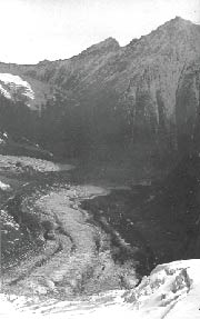
Figure 19.--View from the summit of Cerro Alto (6,111 m) looking to the east-northeast. Photographed by Luis Krahl on 20 January 1946 during the first ascent of the mountain. Compare with the vertical aerial photograph (fig. 12). Much more bare glacier ice can be noted in 1946 between the looped moraines of the unnamed glacier than in 1973, which denotes the recentness of a surge.
A surging glacier may dam a river and create an ephemeral lake. This has been the case for Río del Plomo, a river that drains the most heavily glaciated area of the Argentine Central Andes (central part of fig. 9). (This river is a tributary of the Río Tupungato, but it discharges more water than the latter at their confluence. In the same way, Río Tupungato is a tributary of Río Mendoza, although it discharges more water at their confluence. In former times, the name of a river was maintained upstream along the most frequented track, without consideration of the discharge. In case of doubt, confluent rivers were each named differently from the one downstream.)
Río del Plomo has been dammed at least three times by Glaciar Grande del Nevado (fig. 20). This glacier originates in a large cirque on the southeast side of Nevado del/el Plomo (6,050 m). It then flows from 4,500 m to 3,500 m over a distance of more than 5 km and is covered by an ablation moraine. Along its course, it receives a tributary from Cerro Risopatrón, improperly called Glaciar Pequeño (small) del Nevado. To dam Río del Plomo, Glaciar Grande del Nevado must advance down to 3,200 m and make contact with an outcrop of polished rock (Roca Pulida) on the east bank of Río del Plomo.
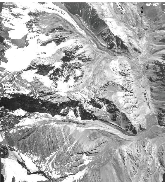
Figure 20.--Origin of the disastrous flood of 1934 (see text). The vertical aerial photograph (from IFTA, 1973) shows the Río del Plomo valley on the right (about 3,100 m asl). At the upper right-hand corner of the photograph is the lower end of Glaciar Oriental del Juncal No. 2, as named by R. Helbling. (The name is abbreviated to Glaciar Juncal E-2. Numbers 1 and 2 are reversed in the map by Lliboutry, 1956). At the upper left of the photograph is Glaciar Juncal E-1; below it, a white glacier has two tongues (Alfa and Beta), and another has a debris-covered gray tongue (Gamma). Nevado del/el Plomo (6,050 m) appears on the left in the central part of the photograph. From the cirque flows Glaciar Grande del Nevado, its heavily debris-covered terminus ending about 2 km from Río del Plomo. Helbling surveyed the region in 1919. At that time, Glaciar Beta and Glaciar Gamma joined Glaciar Juncal E-1, which, in turn, joined Glaciar Juncal E-2, the latter being 3 km longer than at present. Glaciar Grande del Nevado reached Río del Plomo, and tongues of drift attest to this older position of the glacier.
The first known flood due to the rupture of such a dam happened on 2 January 1788. The lake had existed in February 1786 according to the historian Prieto (1986). This conscientious historian did not find a record of any similar event during the 19th century. Therefore, the flood of 10 January 1934, which destroyed bridges and 12.6 km of railroad along Río Mendoza, was quite a surprise (Helbling, 1935). Inspection of the site showed that Glaciar del Nevado had advanced 900 m since its last inspection, 22 years before. It had produced a lake 3 km long, with a maximum depth of 75 m. Clean white ice overthrusted the old moraine. The duration of the advance was unknown and controversial (Espizúa, 1986).
Pertinent Landsat MSS and Thematic Mapper (TM) imagery has been studied by Espizúa and Bengochea (1990) in order to monitor recent movement. It shows that from March 1976 to 16 February 1984, Glaciar del Nevado was covered with debris and ended 2.7 km west of Roca Pulida. On an image of 4 April 1984, the glacier terminus was free of supraglacier drift and had advanced 500 m. Thus, in less than 48 days, the upper part of Glaciar del Nevado had overthrust the lower part. It shows that the friction coefficient of ice over debris-covered ice is only about 0.2.
On a 26 August 1984 image, Glaciar del Nevado had advanced 2 km farther and was only 150 m from Roca Pulida. No further advance is seen on a 13 October 1984 image. Contact with Roca Pulida happened between 22 October and 14 November 1984, and the lake began to form some days later. On 9 January 1985, the lake had reached 2.8 km in length and 1.1 km in width. The potential hazard raised concern by the authorities, but this time, the lake emptied progressively by having peak discharges on 13-15 and 22 February 1985 and on 13 March 1985.
Also in 1984, Glaciar Horcones Inferior (no. 4 in fig. 9), on the south face of Cerro Aconcagua, surged. Given the frequent transit of this valley by groups climbing Cerro Aconcagua, we can be certain that this glacier had not surged during the 20th century.
With the exception of these surges, which are not a common rule, the glaciers of the Central Andes have been strongly receding in recent times. Glaciar Olivares Beta (no. 11 in fig. 9) receded by almost 1 km between 1956 and 1976. In the upper Río del Plomo valley, a comparison of the survey by Helbling in 1919 with the aerial view taken in 1973 (fig. 20) and a Landsat image acquired in 1976 (fig. 9) shows that, in 1919, Glaciar Alto del Río Plomo and Glaciar Bajo del Río Plomo (nos. 5 and 6 in fig. 9) joined Glaciar Juncal E-2 (no. 7 in fig. 9) to form a single valley glacier 16.7 km long. Today, a large gap exists between them. However, because Río del Plomo is flowing freely along the west side of Glaciar Juncal E-2 (Glaciar Oriental del Juncal No. 2), no dangerous lake should form there (fig. 20).
"U-shaped" valleys and moderate subaerial erosion prove that the inner parts of the Dry Andes south of Cerro Aconcagua have been covered with ice several times in the past. The limits of this heavily glaciated area can be observed on Landsat imagery. However, remote sensing from space (or from the air) does not provide evidence for the extension of past glaciers, in particular those that, in more ancient times, should have reached the Central Valley of Chile. The three reasons for this are
In the field along the Argentine Río Mendoza and the Chilean Río Juncal-Aconcagua, which flow in opposite directions, the following morainic systems have been recognized (Caviedes and Paskoff, 1975; Espizúa, 1993):
| Chilean side | Argentine side |
|---|---|
| Portillo (2,650 m) | Horcones (2,750 m) |
| Ojos de Agua (2,100 m) | Penitentes (2,500 m) |
| Guardia Vieja (1,600 m) | Punta de Vacas (2,350 m) |
| Salto del Soldado (1,300 m) | Uspallata (1,870 m) |
Today, large glaciers in the region flow down to 3,000-3,600 m on the Chilean side and down to 3,200-3,800 m on the Argentine side. The lowest, oldest moraines should correspond in the Río Maipo drainage basin (southwestern part of fig. 9) to moraines at 1,400-1,800 m, in particular the huge moraine in the Río Yeso valley studied by Marangunic and Thiele (1971) (south-central part of fig. 9).
According to Espizúa (1993), the glacial drift of the Uspallata morainic system is older than 360 ka (103 years). Therefore, a moraine that has abundant pumice and was deposited by a piedmont glacier at Pudahuel (Santiago airport, 600 m) should be even older. It might have been deposited at 1.2 Ma (106 years), the time of the largest glaciation in Patagonia. At the Santiago site, the moraine has been covered by fluvial sediments. Corings reveal other fluvial sediments below the pumice moraine and, below that, very old and altered glacial drift. We speculate that this altered drift may be of the same age (3.5 Ma) as the glacial drift discovered by Mercer and Sutter (1982) in Patagonia.
Kuhle (1985) found erratic boulders 7.5 km upstream from Punta de Vacas at 3,620 m, 1,020 m above the bottom of the valley. If they were deposited by the glacier ending at Uspallata, 51 km downstream, the mean surface slope of this "Ice Age" glacier would have been 3.43 percent. It was surrounded by summits 800 m higher. These figures are very similar to the ones for the Batura Glacier (Karakoram, Pakistan), which has been thoroughly studied by a Chinese group (Batura Glacier Investigation Group, 1976, 1980). The ablation zone of the Batura Glacier is a valley glacier 43.5 km long that has a mean slope of 3.55 percent. Therefore, we may assume similar balances and temperatures. The Uspallata Glacier probably had an ELA at about 4,000 m (instead of the present 5,000-m ELA in this area). In fact, it was less than 4,000 m because of the subsequent uplift of the Andes Mountains by several hundred meters. At that elevation, the mean air temperature was about -5°C, and the mean precipitation over the glacier was the equivalent of about 1.35 m of water per year, a value that is now reached 200-250 km farther to the south. Thus, contrary to Kuhle's assertion, the lowering of the air temperatures was small and might only have compensated for the somewhat lower elevation of the Andes. As already suggested by Viers (1965) and by Caviedes and Paskoff (1975), the main factor of the "Ice Age" was a northward shift of the rainy province. Lower mean temperatures on a global scale might have caused this shift of the general atmospheric circulation.
| Home | Next |
U.S. Geological Survey, U.S.Department of the Interior