GLACIERS OF SOUTH AMERICA--
GLACIERS OF CHILE AND ARGENTINA
By LOUIS LLIBOUTRY1
With a section on ROCK GLACIERSBy ARTURO E. CORTE
The glaciers of Chile and Argentina appear as glacierets, mountain glaciers, valley glaciers, cirque glaciers, outlet glaciers, piedmont glaciers, ice caps, and ice fields along the more than 4,000-km length of the Andes Mountains in these countries. Here, the glaciers extend from the southern border of Perú at lat 17°30'S. to the southern tip of South America at lat 55°S. They range in size from very small glacierets or snow patches found on the isolated volcanoes of northern Chile (Lliboutry and others, 1958) to the 13,000-km2 Southern Patagonian Ice Field at lat 49°S.
The climate and topography vary along the length of the Andes Mountains, creating different environments for the formation of glaciers. For this reason, the discussion of the glacierized areas is divided into the Dry Andes2, covering the region from lat 17°30'S. to 35°S., and the Wet Andes, covering the region south of lat 35°S. The Dry Andes section has been further divided into the Desert Andes from lat 17°30'S. to 31°S. and the Central Andes from lat 31° to 35°S. (fig. 1). The Wet Andes section has been further divided into two parts north and south of lat 45°30'S. The northern part includes the Región de los Lagos (Lakes Region) but extends farther north and south. The southern part is now called the Patagonian Andes. (Historical Patagonia was all the land south of lat 37°S.)
In the Desert Andes, arid conditions limit the ice-and-snow formation to small patches on the highest peaks (Lliboutry and others, 1958). North of lat 28°S., these ice-and-snow patches are found on individual volcanoes, some of which are more than 6,000 m in elevation (González-Ferrán, 1995). South of lat 28°S., isolated volcanoes do not exist. Here, most of the small ice-and-snow areas are found on the main range, which is the border between Argentina and Chile. Farther south, in the Central Andes between lat 31° and 35°S., true glaciers flowing at the head of valleys exist because of higher mountains and greater precipitation. The total area of uncovered and debris-covered glaciers here is about 2,200 km2.
The Wet Andes south of lat 35°S. have a much greater amount of precipitation. Between lat 35° and 45°30'S., west of the continuous range that forms the water divide and the border, more than 35 isolated volcanoes have elevations high enough to support glacier ice. However, owing to a decrease in the elevation of the main cordillera, no cirque glaciers are present in this range until about lat 41°S. South of lat 41°S., a few cirque glaciers appear and then become numerous. It is not until about lat 44°25'S. that they are large enough to be delineated on Landsat multispectral scanner (MSS) images. South of lat 45°30'S. in the Patagonian Andes, a very large number of mountain glaciers, outlet glaciers, and ice fields are located, including the 4,200-km2 Northern Patagonian Ice Field, the 13,000- km2 Southern Patagonian Ice Field, and the 2,300-km2 ice field of Cordillera Darwin in the southwest corner of Tierra del Fuego.
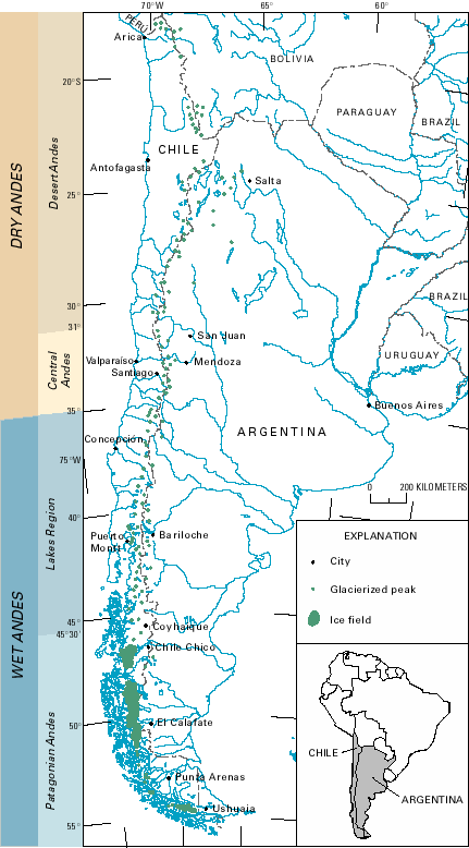
Figure 1.--Chile and Argentina showing the occurrence of glaciers in the Dry Andes (Desert Andes and Central Andes) and in the Wet Andes (Lakes Region and Patagonian Andes) and location of towns and cities near the glacierized areas that have airports.
The variation in the size and occurrence of glaciers in Chile and Argentina is a result of the interaction of topography and climate. As seen in figure 2, the lowering of the equilibrium line altitude (ELA) going southward is progressive, whereas the Andes Mountains are very much lower south of lat 35°S. Therefore, large glaciers are found in the Central Andes (lat 31° to 35°S.), but between lat 35° and 42°S., ice is found only on isolated volcanoes, which are the highest summits there. Moreover, in the Central Andes, because all humidity comes from the Pacific Ocean, the ELA at a given latitude rises by about 1,500 m from west to east (see fig. 6).
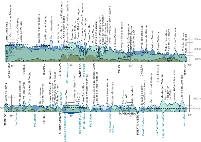
Figure 2.--Southern Andes seen from the west. Green-tinted low area is the Coast Range (Cordillera de la Costa). The dashed line represents the glaciation level. Mountain summits above the glaciation level are shown in a lighter tint, although in the Central Andes (lat 31°S. to lat 35°S.) they are not totally ice covered. The lighter tinted areas have also been extended down to the elevation reached by the main glaciers (modified from Lliboutry, 1956).
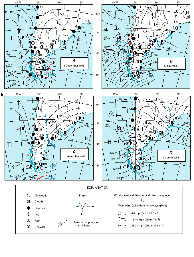
In the most frequent, "normal" meteorological situation, a belt of stationary high pressure extends across South America at about lat 35°S., which thereby prevents any intrusion of moisture-laden airmasses into the continent. One anticyclone (atmospheric high pressure system with winds blowing spirally outward; in the Southern Hemisphere, the winds travel in a counter-clockwise direction) is situated permanently on the west coast over the Pacific Ocean and another on the Atlantic coast. To the south, a steep north-south atmospheric-pressure gradient induces strong, moisture-laden westerly winds to flow over Patagonia (south of lat 45°30'S. in fig. 3A). Consequently, western Patagonia has heavy precipitation, whereas the northern part of Chile is a hyperarid desert.
During the year, the anticyclones fluctuate in latitudinal position. Normally from May to September, they are located at lower latitudes, which allows moist air masses from the southwest to reach the Andes Mountains and results in some very heavy snowfalls (fig. 3B). This influence can extend northward as far as lat 28°S. North of lat 24°S. on the very high Puna, local convection provides some storms with snowfall, however.
From October to April, as a rule, the anticyclones are found at higher latitudes. Moisture from the Amazon basin reaches Perú and the Cordillera Oriental of Bolivia. Some precipitation coming from the northeast can also reach the Altiplano (the very high, semiarid plateau) as far as lat 25°S. The Pacific anticyclone can even extend over Patagonia, which results in a south wind, fine weather, and a cloudless sky over the Patagonian Andes, a rare event (fig. 3C).
Other synoptic weather patterns are also possible. In particular, between the Pacific and Atlantic anticyclones, cool and humid Atlantic maritime airmasses can invade central Argentina, a situation called Sudestada (southeasterly wind regime). Figures 3C and 3D illustrate two extreme cases. In the first, rain in the lowlands and snow in the Andes are found in Provincia del Neuquén (between the Provincia de Mendoza and Lago Nahuel Huapí) (about lat 36° to 40°S.). In this case, the Central Andes only have light snowfall. In the second case, the Sudestada wind pattern extends over Uruguay as far as the Provincia de Tucumán, especially affecting the Nevados de Aconquija at about lat 27°S. Under these meteorological conditions, no precipitation results in the Central Andes.
The three possible sources of moisture to the Dry Andes, in decreasing order, are the southwest, southeast, and northeast. This explains why the driest Andes are found on the west border of the Altiplano between lat 20° and 28°S.
|
|
|||||||||||||||||||||||||||||
Figure 3.--Selected synoptic meteorological charts of southern South America as published in "El Mercurio" (Santiago): A, The most frequent meteorological conditions: high-pressure systems (H) located at about lat 35°S. prevent moisture from reaching the central and northern parts of the Andes but allow moisture-laden winds over Patagonia in the south; B, High-pressure systems located farther north permit moisture-laden air from the southwest to reach the Central Andes (lat 31°S. to lat 35°S.); C, Sudestada (southeasterly wind regime) in Provincia del Neuquén, and an area of high pressure over Patagonia. Moisture coming from the northeast can reach as far as lat 25°S.; and D, Sudestada in northern Argentina. No precipitation is found in the Central Andes. Regions of low pressure are indicated with an L.
As a rule, the Andes Mountains of Chile and Argentina have neither inhabitants nor roads. This fact, combined with the very high elevations of the Dry Andes and the very bad weather and often impenetrable rain forest of most of the Wet Andes, makes the study of their glaciers very difficult. Under such conditions, remotely sensed data provide a valuable tool to aid in the monitoring of glacierized areas. Remotely sensed data, and particularly Landsat data, can be used to determine the occurrence of glaciers in some areas, to delineate areal extent, where not obscured by debris cover, and to monitor snowline variation, glacier surges, and volcanic events that affect glacier areas. Figure 4 and table 1 show the optimum Landsat 1, 2, and 3 MSS and return beam vidicon (RBV) images that have been evaluated for glaciological applications and are available from the U.S. archive at the EROS Data Center, Sioux Falls, S. Dak. More recent Landsat data are also available from the EROS Data Center and from receiving stations in South America.
Figure 4.--Optimum Landsat 1, 2, and 3 images of the glaciers of Chile and Argentina.
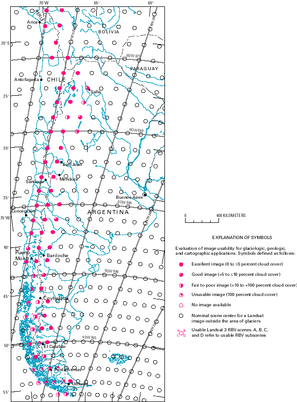
Table 1.--Optimum Landsat 1, 2, and 3 images of the glaciers of Chile and Argentina
Manuscript approved for publication 18 March 1998.
1 3, Avenue de la Foy, 38700 Corenc, France.
2 Geographic place-names in this section conform to the usage recommended by the U.S. Board on Geographic Names in the gazetteers of Argentina (1992a), Chile (1967, 1992c), Peru (1989), and Bolivia (1992b). Where a feature on the border of Argentina and Chile has a different name in each country, both names are given separated by a slash, the Argentine name listed first. Names not listed in the gazetteer for any of the countries are shown in italics, or in quotation marks if the place-name is already italicized in an illustration.
| Home | Next |
U.S. Geological Survey, U.S.Department of the Interior