![]()
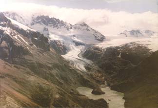
Figure 36.--Head of the valley of the Río Eléctrico, just north of the FitzRoy group. Photograph taken from a helicopter looking toward the west-northwest on 29 November 1993 by Louis Lliboutry. Left: Cordón Marconi. Bottom right: very slightly marked Paso Marconi (1,498 m) on the international border, a route to the Southern Patagonian Ice Field, and behind, in the distance, Cordón GAEA. Middle: Glaciar Marconi; it does not reach Laguna Eléctrico (bottom), as was the case in 1952. On the bottom-left corner, a shoulder of moraine and scree indicates the level of the glacier that entered Valle Eléctrico through Paso Marconi during the last glacial maximum.
| Click the "Close" box to exit this window. |
U.S. Geological Survey, U.S.Department of the Interior