![]()
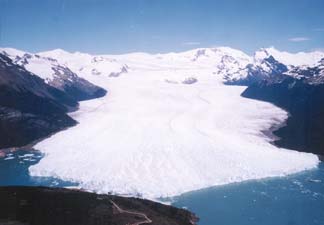
Figure 39.--Looking west at Glacier (Perito) Moreno from Cerro Buenos Aires. The water to the left is Brazo Rico, and to the right is Canal de los Témpanos of Lago Argentino. In between, where the ice dam forms, the access road to the tourist sightseeing area called "El Mirador" is visible. The mountains in the background, including Cerro Pietrobelli (2,950 m), the highest in this region, divide the ice draining eastward into Lago Argentino and westward (not visible) into fjords of the Pacific Ocean. Photograph taken on 5 December 1996 courtesy of Pedro Skvarca, Instituto Antártico Argentino, División Glaciología, Buenos Aires, Argentina.
| Click the "Close" box to exit this window. |
U.S. Geological Survey, U.S.Department of the Interior